
Vielen Dank für die Unterstützung dieser Website ❤️
Spenden
Spenden
Topografische Karte Saylorsburg
Klicken Sie auf die Karte, um die Höhe anzuzeigen.
Vielen Dank für die Unterstützung dieser Website ❤️
Spenden
Spenden
Saylorsburg
Saylorsburg is home to some species of wildlife, including American Black Bear, Gray & Red Fox, White-Tailed Deer, Groundhog, Virginia Opossum, Raccoon, and Fisher. As well, Saylorsburg is also home to several bird species including Great Blue Heron, Wild Turkey, and Bald Eagle. Although they are not known to be present in Saylorsburg (very few sightings), it is commonly known that Elk reside in higher elevations in the Pocono Mountains.
Vielen Dank für die Unterstützung dieser Website ❤️
Spenden
Spenden
Über diese Karte
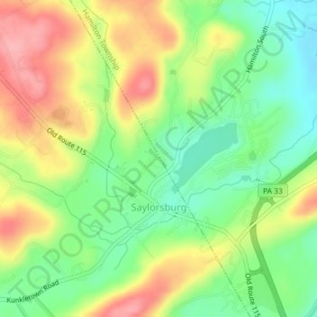
Name: Topografische Karte Saylorsburg, Höhe, Relief.
Durchschnittliche Höhe: 225 m
Minimale Höhe: 173 m
Maximale Höhe: 289 m
Vielen Dank für die Unterstützung dieser Website ❤️
Spenden
Spenden