Geolokalisieren
👉 Easily get elevation data in JSON, GeoTIFF and KML formats using Elevation API
Vielen Dank für die Unterstützung dieser Website ❤️
Spenden

Topografische Karte Magnolia

Klicken Sie auf die Karte, um die Höhe anzuzeigen.

👉 Easily get elevation data in JSON, GeoTIFF and KML formats using Elevation API
Vielen Dank für die Unterstützung dieser Website ❤️
Spenden

Über diese Karte

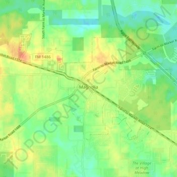
Name: Topografische Karte Magnolia, Höhe, Relief.

Ort: Magnolia, Montgomery County, Texas, 77353, United States (30.18961 -95.77650 30.22826 -95.69937)

Durchschnittliche Höhe: 77 m

Minimale Höhe: 58 m

Maximale Höhe: 102 m

👉 Easily get elevation data in JSON, GeoTIFF and KML formats using Elevation API
Vielen Dank für die Unterstützung dieser Website ❤️
Spenden

Andere topografische Karten

Klicken Sie auf eine Karte, um ihre Topografie, ihre Höhe und ihr Relief anzuzeigen.

New Caney

United States > Texas > Montgomery County

Durchschnittliche Höhe: 30 m

Stillwater Community

United States > Texas > Montgomery County > Conroe

Durchschnittliche Höhe: 44 m

Mount Zion

United States > Texas > Montgomery County

Durchschnittliche Höhe: 88 m

Bobville

United States > Texas > Montgomery County

Durchschnittliche Höhe: 75 m

Vielen Dank für die Unterstützung dieser Website ❤️
Spenden

Wild Ridge

United States > Texas > Montgomery County > The Woodlands

Durchschnittliche Höhe: 44 m

Conroe

United States > Texas > Montgomery County > Conroe > Conroe

Durchschnittliche Höhe: 60 m

Benders Landing

United States > Texas > Montgomery County

Durchschnittliche Höhe: 29 m

Sterling Ridge

United States > Texas > Montgomery County > The Woodlands

Durchschnittliche Höhe: 58 m

Vielen Dank für die Unterstützung dieser Website ❤️
Spenden

Security

United States > Texas > Montgomery County

Durchschnittliche Höhe: 53 m

Porter

United States > Texas > Montgomery County

Durchschnittliche Höhe: 30 m

Woodland Hills

United States > Texas > Montgomery County > Conroe

Durchschnittliche Höhe: 99 m

Stillwater Community

United States > Texas > Montgomery County > Conroe

Durchschnittliche Höhe: 44 m

Vielen Dank für die Unterstützung dieser Website ❤️
Spenden

Indian Springs

United States > Texas > Montgomery County > The Woodlands

Durchschnittliche Höhe: 48 m

LITTLE LAKE CONROE

United States > Texas > Montgomery County > Conroe

Durchschnittliche Höhe: 77 m

New Caney

United States > Texas > Montgomery County

Durchschnittliche Höhe: 30 m

Vielen Dank für die Unterstützung dieser Website ❤️
Spenden