
Vielen Dank für die Unterstützung dieser Website ❤️
Spenden
Spenden
Topografische Karte Las Cuevas
Klicken Sie auf die Karte, um die Höhe anzuzeigen.
Vielen Dank für die Unterstützung dieser Website ❤️
Spenden
Spenden
Über diese Karte
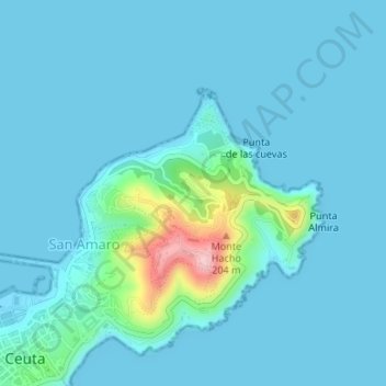
Name: Topografische Karte Las Cuevas, Höhe, Relief.
Durchschnittliche Höhe: 21 m
Minimale Höhe: -1 m
Maximale Höhe: 192 m
Vielen Dank für die Unterstützung dieser Website ❤️
Spenden
Spenden
Andere topografische Karten
Klicken Sie auf eine Karte, um ihre Topografie, ihre Höhe und ihr Relief anzuzeigen.
Ceuta
La morfología del terreno ceutí se debe al plegamiento alpino, que fraccionó esta tierra hasta la gran plataforma del Sáhara. Su principal accidente orográfico es el monte Hacho, formado por un anticlinal. El resto lo constituye un istmo que une el Hacho con el continente africano y un islote conocido…
Durchschnittliche Höhe: 76 m