
Spenden
Topografische Karte Arnison Crag
Klicken Sie auf die Karte, um die Höhe anzuzeigen.
Spenden
Arnison Crag
Although properly a northeastern ridge of Birks and having little topographical prominence, Arnison Crag was classed as a separate fell by Alfred Wainwright in his Pictorial Guide to the Lakeland Fells. That convention is followed here. In support of his decision he referred to it as ‘a low hill with a summit worthy of a mountain’.
Spenden
Über diese Karte
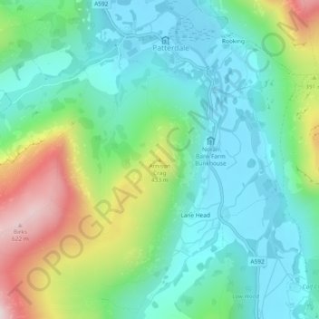
Name: Topografische Karte Arnison Crag, Höhe, Relief.
Durchschnittliche Höhe: 287 m
Minimale Höhe: 147 m
Maximale Höhe: 635 m
Spenden
Andere topografische Karten
Klicken Sie auf eine Karte, um ihre Topografie, ihre Höhe und ihr Relief anzuzeigen.
Brown Cove Tarn
United Kingdom > England > Westmorland and Furness > Patterdale
Durchschnittliche Höhe: 699 m
Hard Tarn
United Kingdom > England > Westmorland and Furness > Patterdale
Durchschnittliche Höhe: 630 m
Brothers Water
United Kingdom > England > Westmorland and Furness > Patterdale > Hartsop
Durchschnittliche Höhe: 298 m
Norfolk Isle
United Kingdom > England > Westmorland and Furness > Patterdale
Durchschnittliche Höhe: 260 m
Spenden