
Vielen Dank für die Unterstützung dieser Website ❤️
Spenden
Spenden
Topografische Karte San Gabriele
Klicken Sie auf die Karte, um die Höhe anzuzeigen.
Vielen Dank für die Unterstützung dieser Website ❤️
Spenden
Spenden
Über diese Karte
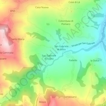
Name: Topografische Karte San Gabriele, Höhe, Relief.
Ort: San Gabriele, Piozzano, Piacenza, Emilia-Romagna, Italia (44.90737 9.46598 44.91151 9.47377)
Durchschnittliche Höhe: 383 m
Minimale Höhe: 238 m
Maximale Höhe: 580 m
Vielen Dank für die Unterstützung dieser Website ❤️
Spenden
Spenden
Andere topografische Karten
Klicken Sie auf eine Karte, um ihre Topografie, ihre Höhe und ihr Relief anzuzeigen.
Castello di Monteventano
Italia > Emilia-Romagna > Piacenza > Piozzano > Castello di Monteventano
Durchschnittliche Höhe: 403 m
Vielen Dank für die Unterstützung dieser Website ❤️
Spenden
Spenden