
Topografische Karte Junction Hill
Interaktive Karte
Klicken Sie auf die Karte, um die Höhe anzuzeigen.
Über diese Karte
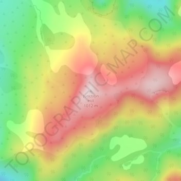
Name: Topografische Karte Junction Hill, Höhe, Relief.
Ort: Junction Hill, Westland District, West Coast, New Zealand (-44.22940 168.33378 -44.22930 168.33388)
Durchschnittliche Höhe: 784 m
Minimale Höhe: 542 m
Maximale Höhe: 1.013 m
Andere topografische Karten
Klicken Sie auf eine Karte, um ihre Topografie, ihre Höhe und ihr Relief anzuzeigen.
De La Beche
New Zealand > West Coast > Westland District
De La Beche, Westland District, West Coast, New Zealand
Durchschnittliche Höhe: 2.480 m
Hidden Peak
New Zealand > West Coast > Westland District
Hidden Peak, Westland District, West Coast, New Zealand
Durchschnittliche Höhe: 1.877 m
Haast
New Zealand > West Coast > Westland District
Haast, Westland District, West Coast, New Zealand
Durchschnittliche Höhe: 15 m
Fox Glacier
New Zealand > West Coast > Westland District
Fox Glacier, Westland District, West Coast, New Zealand
Durchschnittliche Höhe: 1.836 m
Franz Josef Glacier
New Zealand > West Coast > Westland District
Franz Josef Glacier, Westland District, West Coast, New Zealand
Durchschnittliche Höhe: 1.709 m
Amherst Glacier
New Zealand > West Coast > Westland District
Amherst Glacier, Westland District, West Coast, New Zealand
Durchschnittliche Höhe: 1.819 m