
Topografische Karte Flanagan
Interaktive Karte
Klicken Sie auf die Karte, um die Höhe anzuzeigen.
Über diese Karte
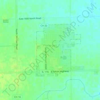
Name: Topografische Karte Flanagan, Höhe, Relief.
Ort: Flanagan, Livingston County, Illinois, United States (40.86972 -88.86602 40.88380 -88.85023)
Durchschnittliche Höhe: 206 m
Minimale Höhe: 199 m
Maximale Höhe: 212 m
Andere topografische Karten
Klicken Sie auf eine Karte, um ihre Topografie, ihre Höhe und ihr Relief anzuzeigen.
Pontiac
United States > Illinois > Livingston County
Pontiac, Pontiac Township, Livingston County, Illinois, 61764, United States
Durchschnittliche Höhe: 199 m
Cornell
United States > Illinois > Livingston County
Cornell, Amity Township, Livingston County, Illinois, United States
Durchschnittliche Höhe: 193 m
Cornell
United States > Illinois > Livingston County > Cornell
Cornell, Amity Township, Livingston County, Illinois, 61319, United States
Durchschnittliche Höhe: 192 m
Campus
United States > Illinois > Livingston County > Campus
Campus, Livingston County, Illinois, 60920, United States
Durchschnittliche Höhe: 200 m
Odell
United States > Illinois > Livingston County
Odell, Livingston County, Illinois, 60460, United States
Durchschnittliche Höhe: 218 m