
Topografische Karte Municipio de San Luis del Palmar
Interaktive Karte
Klicken Sie auf die Karte, um die Höhe anzuzeigen.
Über diese Karte
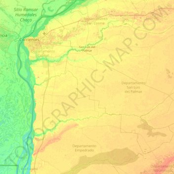
Name: Topografische Karte Municipio de San Luis del Palmar, Höhe, Relief.
Durchschnittliche Höhe: 60 m
Minimale Höhe: 37 m
Maximale Höhe: 88 m
Andere topografische Karten
Klicken Sie auf eine Karte, um ihre Topografie, ihre Höhe und ihr Relief anzuzeigen.
Municipio de Alvear
Municipio de Alvear, Departamento General Alvear, Corrientes, 3344, Argentina
Durchschnittliche Höhe: 67 m
Barrio Camba Cuá
Argentina > Corrientes > Corrientes
Barrio Camba Cuá, Seccional 1°, Corrientes, Departamento Capital, Corrientes, W3400AID, Argentina
Durchschnittliche Höhe: 52 m
Barrio Arazaty
Argentina > Corrientes > Corrientes
Barrio Arazaty, Seccional 2°, Corrientes, Departamento Capital, Corrientes, Argentina
Durchschnittliche Höhe: 54 m
San Roque
San Roque, Municipio de San Roque, Departamento San Roque, Corrientes, 3448, Argentina
Durchschnittliche Höhe: 60 m
Municipio de San Cosme
Municipio de San Cosme, Departamento San Cosme, Corrientes, Argentina
Durchschnittliche Höhe: 60 m
Corrientes
Corrientes, Departamento Capital, Corrientes, Argentina
Durchschnittliche Höhe: 53 m
Municipio de San Carlos
Municipio de San Carlos, Departamento Ituzaingó, Corrientes, 3306, Argentina
Durchschnittliche Höhe: 138 m
Municipio de Empedrado
Municipio de Empedrado, Departamento Empedrado, Corrientes, Argentina
Durchschnittliche Höhe: 55 m
Corrientes
Argentina > Corrientes > Corrientes
Corrientes, Departamento Capital, Corrientes, Argentina
Durchschnittliche Höhe: 53 m
Paso de los Libres
Argentina > Corrientes > Paso de los Libres
Paso de los Libres, Municipio de Paso de los Libres, Departamento Paso de los Libres, Corrientes, W3230FLP, Argentina
Durchschnittliche Höhe: 54 m
Barrio Esteros del Ibera
Argentina > Corrientes > Municipio de Curuzú Cuatiá
Barrio Esteros del Ibera, Municipio de Curuzú Cuatiá, Departamento Curuzú Cuatiá, Corrientes, Argentina
Durchschnittliche Höhe: 74 m
Municipio de Santo Tomé
Municipio de Santo Tomé, Departamento Santo Tomé, Corrientes, 3340, Argentina
Durchschnittliche Höhe: 92 m
Santo Tomé
Argentina > Corrientes > Municipio de Santo Tomé
Santo Tomé, Municipio de Santo Tomé, Departamento Santo Tomé, Corrientes, 3340, Argentina
Durchschnittliche Höhe: 72 m
Municipio de Bella Vista
Municipio de Bella Vista, Departamento Bella Vista, Corrientes, 3432, Argentina
Durchschnittliche Höhe: 52 m
Laguna Brava
Argentina > Corrientes > Municipio de Paso de los Libres
Laguna Brava, Barrio militar General San Martín, Municipio de Paso de los Libres, Departamento Paso de los Libres, Corrientes, Argentina
Durchschnittliche Höhe: 52 m
Barrio San Martin
Argentina > Corrientes > Municipio de Santo Tomé
Barrio San Martin, Santo Tomé, Municipio de Santo Tomé, Departamento Santo Tomé, Corrientes, Argentina
Durchschnittliche Höhe: 78 m
Municipio de Paso de los Libres
Municipio de Paso de los Libres, Departamento Paso de los Libres, Corrientes, Argentina
Durchschnittliche Höhe: 67 m
Municipio de Esquina
Municipio de Esquina, Departamento Esquina, Corrientes, Argentina
Durchschnittliche Höhe: 35 m
Sauce
Sauce, Municipio de Sauce, Departamento Sauce, Corrientes, Argentina
Durchschnittliche Höhe: 64 m
Municipio de Colonia Liebig's
Municipio de Colonia Liebig's, Departamento Ituzaingó, Corrientes, 3358, Argentina
Durchschnittliche Höhe: 148 m
Municipio de Lavalle
Municipio de Lavalle, Departamento Lavalle, Corrientes, 3443, Argentina
Durchschnittliche Höhe: 43 m
Municipio de Concepción
Municipio de Concepción, Departamento Concepción, Corrientes, 3423, Argentina
Durchschnittliche Höhe: 65 m
Municipio de Itá Ibaté
Municipio de Itá Ibaté, Departamento General Paz, Corrientes, 3480, Argentina
Durchschnittliche Höhe: 68 m
Municipio de Mercedes
Municipio de Mercedes, Departamento Mercedes, Corrientes, Argentina
Durchschnittliche Höhe: 70 m
Paso de la Patria
Argentina > Corrientes > Paso de la Patria
Paso de la Patria, Municipio de Paso de la Patria, Departamento San Cosme, Corrientes, 3904, Argentina
Durchschnittliche Höhe: 52 m
Monte Caseros
Argentina > Corrientes > Monte Caseros
Monte Caseros, Municipio de Monte Caseros, Departamento Monte Caseros, Corrientes, 3220, Argentina
Durchschnittliche Höhe: 48 m
Corrientes
Corrientes, Departamento Capital, Corrientes, Argentina
Durchschnittliche Höhe: 53 m
Costanera Sur
Argentina > Corrientes > Corrientes
Costanera Sur, Seccional 2°, Corrientes, Departamento Capital, Corrientes, Argentina
Durchschnittliche Höhe: 52 m
Loreto
Argentina > Corrientes > Municipio de Loreto
Loreto, Municipio de Loreto, Departamento San Miguel, Corrientes, 3483, Argentina
Durchschnittliche Höhe: 75 m
Goya
Argentina > Corrientes > Goya
Goya, Municipio de Goya, Departamento Goya, Corrientes, W3450, Argentina
Durchschnittliche Höhe: 37 m
Municipio de Ituzaingó
Municipio de Ituzaingó, Departamento Ituzaingó, Corrientes, Argentina
Durchschnittliche Höhe: 79 m
Municipio de Curuzú Cuatiá
Municipio de Curuzú Cuatiá, Departamento Curuzú Cuatiá, Corrientes, Argentina
Durchschnittliche Höhe: 73 m
Municipio de Goya
Municipio de Goya, Departamento Goya, Corrientes, Argentina
Durchschnittliche Höhe: 42 m
Curuzú Cuatiá
Argentina > Corrientes > Curuzú Cuatiá
Curuzú Cuatiá, Municipio de Curuzú Cuatiá, Departamento Curuzú Cuatiá, Corrientes, 3460, Argentina
Durchschnittliche Höhe: 73 m
Municipio de La Cruz
Municipio de La Cruz, Departamento San Martín, Corrientes, 3346, Argentina
Durchschnittliche Höhe: 70 m
Gobernador Agrónomo Valentín Virasoro
Argentina > Corrientes > Gobernador Agrónomo Valentín Virasoro
Gobernador Agrónomo Valentín Virasoro, Municipio de Gobernador Virasoro, Departamento Santo Tomé, Corrientes, Argentina
Durchschnittliche Höhe: 137 m
Islas Apipé
Argentina > Corrientes > General Uriburu
Islas Apipé, , General Uriburu, Municipio de San Antonio, Departamento Ituzaingó, Corrientes, Argentina
Durchschnittliche Höhe: 67 m
Victor Colas
Argentina > Corrientes > Corrientes
Victor Colas, Corrientes, Departamento Capital, Corrientes, 3400, Argentina
Durchschnittliche Höhe: 61 m
Ituzaingó
Argentina > Corrientes > Ituzaingó
Ituzaingó, Municipio de Ituzaingó, Departamento Ituzaingó, Corrientes, 3302, Argentina
Durchschnittliche Höhe: 70 m
Municipio de Mburucuyá
Argentina > Corrientes > Municipio de Mburucuyá
Municipio de Mburucuyá, Departamento Mburucuyá, Corrientes, 3427, Argentina
Durchschnittliche Höhe: 68 m
Río Miriñay
Argentina > Corrientes > Municipio de Mercedes
Río Miriñay, Municipio de Mercedes, Departamento Mercedes, Corrientes, Argentina
Durchschnittliche Höhe: 63 m
Río Miriñay
Río Miriñay, Municipio de Parada Pucheta, Departamento Monte Caseros, Corrientes, Argentina
Durchschnittliche Höhe: 47 m
Yapeyú
Argentina > Corrientes > Yapeyú
Yapeyú, Municipio de Yapeyú, Departamento San Martín, Corrientes, 3231, Argentina
Durchschnittliche Höhe: 54 m
Municipio de Santa Ana
Municipio de Santa Ana, Departamento San Cosme, Corrientes, 3401, Argentina
Durchschnittliche Höhe: 61 m
Bella Vista
Argentina > Corrientes > Bella Vista
Bella Vista, Municipio de Bella Vista, Departamento Bella Vista, Corrientes, 3432, Argentina
Durchschnittliche Höhe: 53 m
Municipio de Monte Caseros
Municipio de Monte Caseros, Departamento Monte Caseros, Corrientes, 3220, Argentina
Durchschnittliche Höhe: 58 m
San Luis del Palmar
Argentina > Corrientes > San Luis del Palmar
San Luis del Palmar, Municipio de San Luis del Palmar, Departamento San Luis del Palmar, Corrientes, W3403, Argentina
Durchschnittliche Höhe: 61 m
Isla Meza
Isla Meza, Corrientes, Departamento Capital, Corrientes, Argentina
Durchschnittliche Höhe: 49 m
San Carlos
Argentina > Corrientes > San Carlos
San Carlos, Municipio de San Carlos, Departamento Ituzaingó, Corrientes, Argentina
Durchschnittliche Höhe: 180 m
Paraje Puerto Valle
Argentina > Corrientes > Municipio de Ituzaingó > Paraje Puerto Valle
Paraje Puerto Valle, Municipio de Ituzaingó, Departamento Ituzaingó, Corrientes, Argentina
Durchschnittliche Höhe: 85 m