Geolokalisieren

Topografische Karte Darbo

Klicken Sie auf die Karte, um die Höhe anzuzeigen.

Über diese Karte

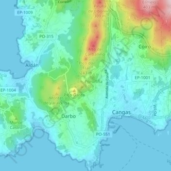
Name: Topografische Karte Darbo, Höhe, Relief.

Ort: Darbo, Cangas, Morrazo, Pontevedra, Galicia, 36949, España (42.24648 -8.81397 42.29905 -8.78139)

Durchschnittliche Höhe: 71 m

Minimale Höhe: -1 m

Maximale Höhe: 405 m

Andere topografische Karten

Klicken Sie auf eine Karte, um ihre Topografie, ihre Höhe und ihr Relief anzuzeigen.

Bueu

España > Galicia > Morrazo

Durchschnittliche Höhe: 91 m

Cangas de Morrazo

España > Galicia > Morrazo

Durchschnittliche Höhe: 54 m

O Beloso

España > Galicia > Morrazo > Bueu > O Beloso

Durchschnittliche Höhe: 172 m

Cano

España > Galicia > Morrazo

Durchschnittliche Höhe: 9 m

A Roza

España > Galicia > Morrazo > Marín

Durchschnittliche Höhe: 175 m

Montemogos

España > Galicia > Morrazo > Bueu

Durchschnittliche Höhe: 43 m

Lago de Castiñeiras

España > Galicia > Morrazo > Marín

Durchschnittliche Höhe: 347 m

Montecelo

España > Galicia > Morrazo > Marín

Durchschnittliche Höhe: 48 m

Soaxe

España > Galicia > Morrazo > Marín

Durchschnittliche Höhe: 69 m

O Igrexario

España > Galicia > Morrazo > Cangas

Durchschnittliche Höhe: 141 m

A Portela

España > Galicia > Morrazo > Bueu

Durchschnittliche Höhe: 187 m

A Estivada

España > Galicia > Morrazo > Marín

Durchschnittliche Höhe: 85 m