
Topografische Karte Bordighera
Interaktive Karte
Klicken Sie auf die Karte, um die Höhe anzuzeigen.
Über diese Karte
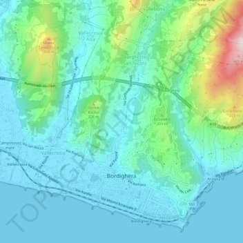
Name: Topografische Karte Bordighera, Höhe, Relief.
Ort: Bordighera, Imperia, Liguria, 18012, Italy (43.77569 7.64626 43.81229 7.70198)
Durchschnittliche Höhe: 102 m
Minimale Höhe: -1 m
Maximale Höhe: 509 m
It is estimated that the previous day had been cloudy with rain, a shower followed by a thunderstorm the night, with long lightning bolts to the east and west, and an elevation of no less than 2500 feet.
Andere topografische Karten
Klicken Sie auf eine Karte, um ihre Topografie, ihre Höhe und ihr Relief anzuzeigen.
Collabassa
Collabassa, Airole, Imperia, Liguria, 18030, Italy
Durchschnittliche Höhe: 313 m
Diano San Pietro
Diano San Pietro, Imperia, Liguria, Italy
Durchschnittliche Höhe: 299 m
I Palanchi
Italy > Liguria > Imperia > Ventimiglia > Torri Inferiore > Torri Superiore
I Palanchi, Torri Superiore, Torri Inferiore, Ventimiglia, Imperia, Liguria, 18030, Italy
Durchschnittliche Höhe: 305 m
Diano Calderina
Diano Calderina, Diano Marina, Imperia, Liguria, 18013, Italy
Durchschnittliche Höhe: 95 m
Ventimiglia
Ventimiglia, Imperia, Liguria, Italy
Durchschnittliche Höhe: 202 m