
Topografische Karte St. Josef am See - San Giuseppe al Lago
Interaktive Karte
Klicken Sie auf die Karte, um die Höhe anzuzeigen.
Über diese Karte
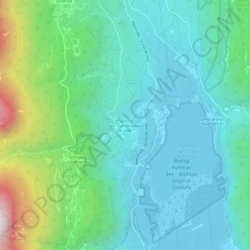
Name: Topografische Karte St. Josef am See - San Giuseppe al Lago, Höhe, Relief.
Durchschnittliche Höhe: 468 m
Minimale Höhe: 203 m
Maximale Höhe: 1.386 m
Andere topografische Karten
Klicken Sie auf eine Karte, um ihre Topografie, ihre Höhe und ihr Relief anzuzeigen.
Biotop Frühlingstal - Biotopo Valle primavera
Italy > Trentino-Alto Adige/Südtirol > South Tyrol > Kaltern an der Weinstraße - Caldaro sulla Strada del Vino
Biotop Frühlingstal - Biotopo Valle primavera, Kaltern an der Weinstraße - Caldaro sulla Strada del Vino, Überetsch-Unterland - Oltradige-Bassa Atesina, South Tyrol, Trentino-Alto Adige/Südtirol, 39052, Italy
Durchschnittliche Höhe: 444 m