
Topografische Karte Market Warsop
Klicken Sie auf die Karte, um die Höhe anzuzeigen.
Über diese Karte
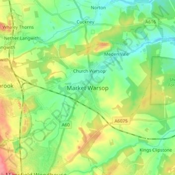
Name: Topografische Karte Market Warsop, Höhe, Relief.
Durchschnittliche Höhe: 79 m
Minimale Höhe: 42 m
Maximale Höhe: 149 m
Andere topografische Karten
Klicken Sie auf eine Karte, um ihre Topografie, ihre Höhe und ihr Relief anzuzeigen.
Sutton in Ashfield
United Kingdom > England > Nottinghamshire > Ashfield > Stanton Hill
Durchschnittliche Höhe: 154 m
Manor House Pond
United Kingdom > England > Nottinghamshire > Broxtowe > Bramcote
Durchschnittliche Höhe: 57 m
Sutton Lawn
United Kingdom > England > Nottinghamshire > Ashfield > Sutton-in-Ashfield
Durchschnittliche Höhe: 155 m
Averham CP
United Kingdom > England > Nottinghamshire > Newark and Sherwood
Durchschnittliche Höhe: 23 m
Southwell CP
United Kingdom > England > Nottinghamshire > Newark and Sherwood
Durchschnittliche Höhe: 47 m
Barton in Fabis
United Kingdom > England > Nottinghamshire > Rushcliffe > Barton-in-Fabis
Durchschnittliche Höhe: 39 m
Sherwood Forest NNR
United Kingdom > England > Nottinghamshire > Newark and Sherwood > Ollerton
Durchschnittliche Höhe: 71 m
Oxton CP
United Kingdom > England > Nottinghamshire > Newark and Sherwood
Durchschnittliche Höhe: 86 m
South Clifton
United Kingdom > England > Nottinghamshire > Newark and Sherwood
Durchschnittliche Höhe: 8 m
Normanton on the Wolds
United Kingdom > England > Nottinghamshire > Rushcliffe
Durchschnittliche Höhe: 59 m
Rolleston CP
United Kingdom > England > Nottinghamshire > Newark and Sherwood
Durchschnittliche Höhe: 16 m
Beckingham
United Kingdom > England > Nottinghamshire > Bassetlaw > Beckingham
Durchschnittliche Höhe: 17 m
Clipstone
United Kingdom > England > Nottinghamshire > Newark and Sherwood
Durchschnittliche Höhe: 89 m
Rufford CP
United Kingdom > England > Nottinghamshire > Newark and Sherwood
Durchschnittliche Höhe: 76 m
Balderton
United Kingdom > England > Nottinghamshire > Newark and Sherwood > Balderton
Durchschnittliche Höhe: 20 m
Kirkby-in-Ashfield
United Kingdom > England > Nottinghamshire > Ashfield
Durchschnittliche Höhe: 145 m
Egmanton CP
United Kingdom > England > Nottinghamshire > Newark and Sherwood
Durchschnittliche Höhe: 50 m
Epperstone CP
United Kingdom > England > Nottinghamshire > Newark and Sherwood
The report notes Epperstone's "very distinctive character... a combination of topography, buildings, trees and walls.... The constantly changing views make it an attractive space to move through." It also notes, "The approach to the village from the west is along a tunnel formed by overhanging trees, including…
Durchschnittliche Höhe: 69 m
Bilsthorpe CP
United Kingdom > England > Nottinghamshire > Newark and Sherwood
Durchschnittliche Höhe: 75 m
Sutton-on-Trent CP
United Kingdom > England > Nottinghamshire > Newark and Sherwood
Durchschnittliche Höhe: 13 m
Woodthorpe Grange Park
United Kingdom > England > Nottinghamshire > Nottingham > Arnold
Durchschnittliche Höhe: 87 m
Radcliffe on Trent
United Kingdom > England > Nottinghamshire > Rushcliffe
Durchschnittliche Höhe: 37 m
Staythorpe CP
United Kingdom > England > Nottinghamshire > Newark and Sherwood
The land is very low-lying and level, varying little in elevation between 12–14 metres (39–46 ft) throughout.
Durchschnittliche Höhe: 16 m
Nottingham Canal
United Kingdom > England > Nottinghamshire > Nottingham > Beeston
Durchschnittliche Höhe: 33 m
Eakring CP
United Kingdom > England > Nottinghamshire > Newark and Sherwood
Durchschnittliche Höhe: 75 m
East Stoke
United Kingdom > England > Nottinghamshire > Newark and Sherwood
Durchschnittliche Höhe: 24 m
Kelham CP
United Kingdom > England > Nottinghamshire > Newark and Sherwood > Newark on Trent
Durchschnittliche Höhe: 23 m
Willoughby on the Wolds
United Kingdom > England > Nottinghamshire > Rushcliffe
Durchschnittliche Höhe: 92 m
River Meden
United Kingdom > England > Nottinghamshire > Mansfield > Warsop Vale
Durchschnittliche Höhe: 71 m
Rhodesia
United Kingdom > England > Nottinghamshire > Bassetlaw > Worksop
Durchschnittliche Höhe: 48 m
Caunton CP
United Kingdom > England > Nottinghamshire > Newark and Sherwood
Durchschnittliche Höhe: 42 m
Ratcliffe on Soar
United Kingdom > England > Nottinghamshire > Rushcliffe
Durchschnittliche Höhe: 36 m
Gonalston CP
United Kingdom > England > Nottinghamshire > Newark and Sherwood
Durchschnittliche Höhe: 42 m
Upton CP
United Kingdom > England > Nottinghamshire > Newark and Sherwood
Durchschnittliche Höhe: 30 m
Ompton CP
United Kingdom > England > Nottinghamshire > Newark and Sherwood
Durchschnittliche Höhe: 79 m
Archers Lake
United Kingdom > England > Nottinghamshire > Rushcliffe > Bingham
Durchschnittliche Höhe: 28 m
Kirton CP
United Kingdom > England > Nottinghamshire > Newark and Sherwood
Durchschnittliche Höhe: 55 m
Collingham CP
United Kingdom > England > Nottinghamshire > Newark and Sherwood
Durchschnittliche Höhe: 15 m
Sturton le Steeple
United Kingdom > England > Nottinghamshire > Bassetlaw
Durchschnittliche Höhe: 20 m
Eastwood
United Kingdom > England > Nottinghamshire > Broxtowe > Newthorpe
Durchschnittliche Höhe: 81 m
Sherwood Forest National Nature Reserve
United Kingdom > England > Nottinghamshire > Newark and Sherwood > Ollerton
Durchschnittliche Höhe: 71 m
Elton-on-the-Hill
United Kingdom > England > Nottinghamshire > Rushcliffe
Elton lies about 14 miles (23 km) east of Nottingham. It straddles the A52 trunk road, from which Station Road runs north towards Orston and Sutton Lane south, with Sutton-cum-Granby being the nearest hamlet in that direction. Elton has a population of 114 people and is in the Rushcliffe district. It has an…
Durchschnittliche Höhe: 29 m
Clipston
United Kingdom > England > Nottinghamshire > Rushcliffe
Clipston stands on the northernmost edge of the Wolds in Nottinghamshire. The area enjoys, from an elevation of about 79 m/259 ft, panoramic views of the Trent valley and the East and South side of the city of Nottingham, some 50 m/164 ft lower. Nearby to the west is Hoe Hill, with a horseshoe-shaped wood.
Durchschnittliche Höhe: 59 m
Edingley CP
United Kingdom > England > Nottinghamshire > Newark and Sherwood
Durchschnittliche Höhe: 63 m
Flintham
United Kingdom > England > Nottinghamshire > Rushcliffe > Flintham
Durchschnittliche Höhe: 37 m
Hockerton CP
United Kingdom > England > Nottinghamshire > Newark and Sherwood
Durchschnittliche Höhe: 54 m
North Muskham CP
United Kingdom > England > Nottinghamshire > Newark and Sherwood
Durchschnittliche Höhe: 11 m