Geolokalisieren
👉 Easily get elevation data in JSON, GeoTIFF and KML formats using Elevation API
Vielen Dank für die Unterstützung dieser Website ❤️
Spenden

Topografische Karte Scuole Ghiarda

Klicken Sie auf die Karte, um die Höhe anzuzeigen.

👉 Easily get elevation data in JSON, GeoTIFF and KML formats using Elevation API
Vielen Dank für die Unterstützung dieser Website ❤️
Spenden

Über diese Karte

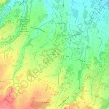
Name: Topografische Karte Scuole Ghiarda, Höhe, Relief.

Ort: Scuole Ghiarda, Rivalta, Reggio Emilia, Reggio nell'Emilia, Emilia-Romagna, Italia (44.64413 10.54400 44.68413 10.58400)

Durchschnittliche Höhe: 100 m

Minimale Höhe: 66 m

Maximale Höhe: 144 m

👉 Easily get elevation data in JSON, GeoTIFF and KML formats using Elevation API
Vielen Dank für die Unterstützung dieser Website ❤️
Spenden

Andere topografische Karten

Klicken Sie auf eine Karte, um ihre Topografie, ihre Höhe und ihr Relief anzuzeigen.

Codemondo

Italia > Emilia-Romagna > Reggio nell'Emilia > Reggio Emilia

Durchschnittliche Höhe: 67 m

Bagno

Italia > Emilia-Romagna > Reggio nell'Emilia > Reggio Emilia

Durchschnittliche Höhe: 54 m

San Pellegrino

Italia > Emilia-Romagna > Reggio nell'Emilia > Reggio Emilia

L'altitudine varia da 60 a 77 m s.l.m.

Durchschnittliche Höhe: 67 m

Gavassa

Italia > Emilia-Romagna > Reggio nell'Emilia > Reggio Emilia

Durchschnittliche Höhe: 43 m

Vielen Dank für die Unterstützung dieser Website ❤️
Spenden

Rivalta

Italia > Emilia-Romagna > Reggio nell'Emilia > Reggio Emilia

Durchschnittliche Höhe: 97 m

Coviolo

Italia > Emilia-Romagna > Reggio nell'Emilia > Reggio Emilia

Durchschnittliche Höhe: 71 m