
Topografische Karte Çaykara
Interaktive Karte
Klicken Sie auf die Karte, um die Höhe anzuzeigen.
Über diese Karte
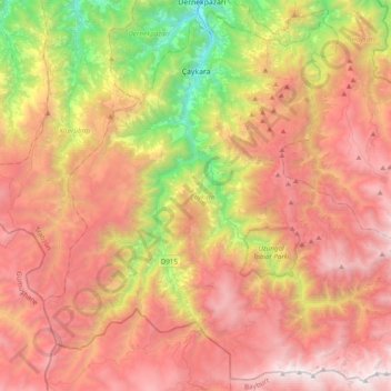
Name: Topografische Karte Çaykara, Höhe, Relief.
Ort: Çaykara, Trabzon, Black Sea Region, Turkey (40.51354 40.09034 40.79261 40.47893)
Durchschnittliche Höhe: 1.797 m
Minimale Höhe: 229 m
Maximale Höhe: 3.224 m
Çaykara (Romeika: Kadahor, Κατωχώρι) is a municipality and district of Trabzon Province, Turkey. Its area is 574 km2, and its population is 13,070 (2022). As of 2023, the Mayor of Çaykara is Hanefi Tok (AKP). Çaykara village lies in a V-shaped valley along the Solaklı River in the Pontic Mountains, at an elevation of around 300 metres. Çaykara district lies to the south of Dernekpazarı (Kondu) and forms the upper part of the Of-valley system ('Solaklı Vadisi' in Turkish), with peaks reaching to over 3300 meters. The western half of İkizdere district - which lies just east of Çaykara and is now part of Rize province - was historically also part of the same administrative and cultural region. Large swathes of the district are made up of old-growth temperate broadleaf and mixed forest, gradually making way for alpine tundra at higher altitudes.
Andere topografische Karten
Klicken Sie auf eine Karte, um ihre Topografie, ihre Höhe und ihr Relief anzuzeigen.
Ortahisar Mahallesi
Ortahisar Mahallesi, Ortahisar, Trabzon, Black Sea Region, Turkey
Durchschnittliche Höhe: 72 m
Atapark
Turkey > Trabzon > Ortahisar > Gülbaharhatun Mahallesi
Atapark, Gülbaharhatun, Gülbaharhatun Mahallesi, Ortahisar, Trabzon, Black Sea Region, Turkey
Durchschnittliche Höhe: 63 m