
Topografische Karte Organ Pipe Cactus National Monument
Interaktive Karte
Klicken Sie auf die Karte, um die Höhe anzuzeigen.
Über diese Karte
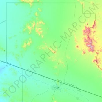
Name: Topografische Karte Organ Pipe Cactus National Monument, Höhe, Relief.
Durchschnittliche Höhe: 494 m
Minimale Höhe: 274 m
Maximale Höhe: 1.418 m
Andere topografische Karten
Klicken Sie auf eine Karte, um ihre Topografie, ihre Höhe und ihr Relief anzuzeigen.
South Fort
USA > Arizona > South Fort
South Fort, Yavapai County, Arizona, USA
Durchschnittliche Höhe: 1.777 m
Castle Mountains
Castle Mountains, Pima County, Arizona, USA
Durchschnittliche Höhe: 741 m
Laguna Mountains
Laguna Mountains, Yuma, Yuma County, Arizona, USA
Durchschnittliche Höhe: 141 m
Sevenmile Mountains
Sevenmile Mountains, Gila County, Arizona, USA
Durchschnittliche Höhe: 1.511 m
John the Baptist Mountains
John the Baptist Mountains, Pima County, Arizona, USA
Durchschnittliche Höhe: 523 m
Granite Mountains
Granite Mountains, Pima County, Arizona, USA
Durchschnittliche Höhe: 394 m
Mount Lemmon
Mount Lemmon, Pima County, Arizona, 85619, USA
Durchschnittliche Höhe: 2.514 m
Superstition Mountains
Superstition Mountains, Pinal County, Arizona, USA
Durchschnittliche Höhe: 1.125 m