
Topografische Karte Al Mandarah
Interaktive Karte
Klicken Sie auf die Karte, um die Höhe anzuzeigen.
Über diese Karte
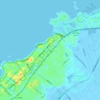
Name: Topografische Karte Al Mandarah, Höhe, Relief.
Ort: Al Mandarah, Alexandria, 71618, Egypt (31.25500 29.98917 31.29500 30.02917)
Durchschnittliche Höhe: 5 m
Minimale Höhe: -5 m
Maximale Höhe: 37 m
Andere topografische Karten
Klicken Sie auf eine Karte, um ihre Topografie, ihre Höhe und ihr Relief anzuzeigen.
Tabyet Agami al Qibliya
Egypt > Alexandria > Agami
Tabyet Agami al Qibliya, Agami, Alexandria, 00203, Egypt
Durchschnittliche Höhe: 0 m
New Borj El Arab
New Borj El Arab, Alexandria, 21934, Egypt
Durchschnittliche Höhe: 32 m
New Borg Al Arab City
New Borg Al Arab City, Alexandria, 21934, Egypt
Durchschnittliche Höhe: 36 m
Abou Qir East
Egypt > Alexandria > Abu Qir
Abou Qir East, Abu Qir, Alexandria, Egypt
Durchschnittliche Höhe: 0 m
Ezbet Wadi al Qamar
Ezbet Wadi al Qamar, Alexandria, 21535, Egypt
Durchschnittliche Höhe: -1 m
Ras al Tin
Egypt > Alexandria > Alexandria
Ras al Tin, Alexandria, 21633, Egypt
Durchschnittliche Höhe: 1 m
Al Hanuvil
Egypt > Alexandria > Al Hanuvil
Al Hanuvil, Alexandria, 21575, Egypt
Durchschnittliche Höhe: 5 m
Iskanderiya
Egypt > Alexandria > Alexandria
Iskanderiya, Alexandria, 21573, Egypt
Durchschnittliche Höhe: 19 m
Qism al Gumruk
Egypt > Alexandria > Alexandria
Qism al Gumruk, Alexandria, 21562, Egypt
Durchschnittliche Höhe: 4 m
Qaryat Shakush
Egypt > Alexandria > Qaryat Shakush
Qaryat Shakush, Alexandria, 23719, Egypt
Durchschnittliche Höhe: 8 m
Bringi Maryut
Egypt > Alexandria > Bringi Maryut
Bringi Maryut, Alexandria, 23511, Egypt
Durchschnittliche Höhe: 14 m
Izbat Muhammad Farid
Izbat Muhammad Farid, Alexandria, 23721, Egypt
Durchschnittliche Höhe: 51 m
El Shallalat
Egypt > Alexandria > Alexandria > Shatby
El Shallalat, Shatby, Alexandria, 21526, Egypt
Durchschnittliche Höhe: 11 m