
Topografische Karte Tate
Interaktive Karte
Klicken Sie auf die Karte, um die Höhe anzuzeigen.
Über diese Karte
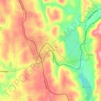
Name: Topografische Karte Tate, Höhe, Relief.
Ort: Tate, Pickens County, Georgia, 30177, United States (34.39843 -84.40270 34.43843 -84.36270)
Durchschnittliche Höhe: 368 m
Minimale Höhe: 270 m
Maximale Höhe: 440 m
Andere topografische Karten
Klicken Sie auf eine Karte, um ihre Topografie, ihre Höhe und ihr Relief anzuzeigen.
Sharp Mountain
United States > Georgia > Pickens County
Sharp Mountain, Pickens County, Georgia, United States
Durchschnittliche Höhe: 516 m
Ludville
United States > Georgia > Pickens County
Ludville, Pickens County, Georgia, United States
Durchschnittliche Höhe: 364 m
Cox Mountain
United States > Georgia > Pickens County
Cox Mountain, Pickens County, Georgia, 30148, United States
Durchschnittliche Höhe: 498 m
Nelson
United States > Georgia > Pickens County
Nelson, Pickens County, Georgia, 30151, United States
Durchschnittliche Höhe: 374 m
Marble Hill
United States > Georgia > Pickens County
Marble Hill, Pickens County, Georgia, 30148, United States
Durchschnittliche Höhe: 404 m
Talking Rock
United States > Georgia > Pickens County
Talking Rock, Pickens County, Georgia, United States
Durchschnittliche Höhe: 383 m
Talking Rock Creek
United States > Georgia > Pickens County > Talking Rock
Talking Rock Creek, Talking Rock, Pickens County, Georgia, 30175, United States
Durchschnittliche Höhe: 373 m
Talking Rock
United States > Georgia > Pickens County > Talking Rock
Talking Rock, Pickens County, Georgia, 30175, United States
Durchschnittliche Höhe: 380 m
Jasper
United States > Georgia > Pickens County > Jasper
Jasper, Pickens County, Georgia, 30142, United States
Durchschnittliche Höhe: 408 m