
Topografische Karte Baramulla
Interaktive Karte
Klicken Sie auf die Karte, um die Höhe anzuzeigen.
Über diese Karte
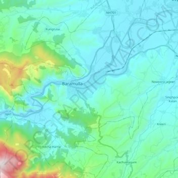
Name: Topografische Karte Baramulla, Höhe, Relief.
Ort: Baramulla, Baramulla district, Jammu and Kashmir, India (34.12147 74.27204 34.28587 74.46668)
Durchschnittliche Höhe: 1.802 m
Minimale Höhe: 1.561 m
Maximale Höhe: 3.208 m
Andere topografische Karten
Klicken Sie auf eine Karte, um ihre Topografie, ihre Höhe und ihr Relief anzuzeigen.
Patnitop
India > Jammu and Kashmir > Ramban
Patnitop, Ramban, Ramban District, Jammu and Kashmir, 182142, India
Durchschnittliche Höhe: 1.793 m
Mendhar
India > Jammu and Kashmir > Mendhar Tehsil
Mendhar, Mendhar Tehsil, Poonch District, Jammu and Kashmir, India
Durchschnittliche Höhe: 1.092 m
Kuther
India > Jammu and Kashmir > Shangus tehsil
Kuther, Shangus tehsil, Anantnag District, Jammu and Kashmir, 192201, India
Durchschnittliche Höhe: 1.862 m
Awantipora
Awantipora, Pulwama District, Jammu and Kashmir, India
Durchschnittliche Höhe: 1.665 m
Tral
Tral, Pulwama District, Jammu and Kashmir, 192123, India
Durchschnittliche Höhe: 2.528 m
Panner Jageer
India > Jammu and Kashmir > Tral
Panner Jageer, Tral, Pulwama District, Jammu and Kashmir, India
Durchschnittliche Höhe: 2.021 m
Chenani
Chenani, Udhampur District, Jammu and Kashmir, India
Durchschnittliche Höhe: 1.812 m
Mular
India > Jammu and Kashmir > Chhatroo > Thaingam
Mular, Thaingam, Chhatroo, Kishtwar District, Jammu and Kashmir, India
Durchschnittliche Höhe: 2.138 m
Bandipora
Bandipora, Jammu and Kashmir, India
Durchschnittliche Höhe: 3.630 m
Sumbal
India > Jammu and Kashmir > Sonawari
Sumbal, Sonawari, Bandipore District, Jammu and Kashmir, India
Durchschnittliche Höhe: 1.594 m
Kriti
India > Jammu and Kashmir > Kokernag Tehsil
Kriti, Kokernag Tehsil, Anantnag District, Jammu and Kashmir, India
Durchschnittliche Höhe: 2.288 m
tsunt War
India > Jammu and Kashmir > Lar > Chunt Valiwar
tsunt War, Chunt Valiwar, Lar, Ganderbal district, Jammu and Kashmir, India
Durchschnittliche Höhe: 2.374 m
maloti
India > Jammu and Kashmir > Bhaderwah
maloti, Bhaderwah, Doda district, Jammu and Kashmir, India
Durchschnittliche Höhe: 1.525 m
Gurez
Gurez, Bandipore district, Jammu and Kashmir, India
Durchschnittliche Höhe: 3.702 m
Akel
India > Jammu and Kashmir > Bani > Dulan
Akel, Dulan, Bani, Kathua District, Jammu and Kashmir, India
Durchschnittliche Höhe: 1.823 m
Tangmarg
India > Jammu and Kashmir > Tangmarg
Tangmarg, Baramulla district, Jammu and Kashmir, India
Durchschnittliche Höhe: 2.776 m
Anantnag district
Anantnag district, Jammu and Kashmir, India
Durchschnittliche Höhe: 2.830 m
Bachhan
India > Jammu and Kashmir > Shangus tehsil
Bachhan, Shangus tehsil, Anantnag district, Jammu and Kashmir, India
Durchschnittliche Höhe: 1.749 m
Amarnath
India > Jammu and Kashmir > Mandi > Amarnath
Amarnath, Mandi, Poonch district, Jammu and Kashmir, 185102, India
Durchschnittliche Höhe: 1.713 m
Arjuna
India > Jammu and Kashmir > Atholi (Paddar)
Arjuna, Atholi (Paddar), Kishtwar district, Jammu and Kashmir, India
Durchschnittliche Höhe: 5.224 m
Kishtwar District
Kishtwar District, Jammu and Kashmir, India
Durchschnittliche Höhe: 3.650 m
Kulgam
Kulgam, Kulgam District, Jammu and Kashmir, India
Durchschnittliche Höhe: 1.818 m
Losar
India > Jammu and Kashmir > Gurez
Losar, Gurez, Bandipore district, Jammu and Kashmir, India
Durchschnittliche Höhe: 3.599 m
Vaishno Devi
India > Jammu and Kashmir > Reasi > Vaishno Devi
Vaishno Devi, Reasi, Reasi district, Jammu and Kashmir, 182301, India
Durchschnittliche Höhe: 1.706 m
Monkey Hills
India > Jammu and Kashmir > Tangmarg > Gulmarg
Monkey Hills, Gulmarg, Tangmarg, Baramulla district, Jammu and Kashmir, 193403, India
Durchschnittliche Höhe: 2.626 m
Bandipora
Bandipora, Bandipore District, Jammu and Kashmir, 193503, India
Durchschnittliche Höhe: 2.703 m
dhalla
India > Jammu and Kashmir > Bhaderwah > dhalla
dhalla, Bhaderwah, Doda District, Jammu and Kashmir, India
Durchschnittliche Höhe: 2.097 m
Kullan
India > Jammu and Kashmir > Kullan
Kullan, Kangan, Ganderbal District, Jammu and Kashmir, India
Durchschnittliche Höhe: 2.529 m
Kathua
Kathua, Kathua District, Jammu and Kashmir, India
Durchschnittliche Höhe: 498 m
Ranbir Singh Pura
India > Jammu and Kashmir > Ranbir Singh Pura
Ranbir Singh Pura, Ranbir Singh Pora, Jammu District, Jammu and Kashmir, 181102, India
Durchschnittliche Höhe: 272 m
Jammu
India > Jammu and Kashmir > Jammu
Jammu, Jammu District, Jammu and Kashmir, 180001, India
Durchschnittliche Höhe: 367 m
Dungti
India > Jammu and Kashmir > Dungti
Dungti, Leh District, Jammu and Kashmir, India
Durchschnittliche Höhe: 4.163 m
Ladakh Range
India > Jammu and Kashmir > Leh
Ladakh Range, Leh, Leh District, Jammu and Kashmir, India
Durchschnittliche Höhe: 4.936 m
Shey
India > Jammu and Kashmir > Shey
Shey, Leh District, Jammu and Kashmir, 194201, India
Durchschnittliche Höhe: 3.282 m
Srinagar
India > Jammu and Kashmir > Srinagar (South)
Srinagar, Srinagar (South), Srinagar District, Jammu and Kashmir, 190001, India
Durchschnittliche Höhe: 1.805 m
Pahalgam
Pahalgam, Anantnag district, Jammu and Kashmir, 192126, India
Durchschnittliche Höhe: 3.265 m
Ganderbal
Ganderbal, Ganderbal district, Jammu and Kashmir, India
Durchschnittliche Höhe: 1.885 m
Kishtwar
Kishtwar, Kishtwar district, Jammu and Kashmir, India
Durchschnittliche Höhe: 2.605 m
Anantnag
Anantnag, Anantnag district, Jammu and Kashmir, India
Durchschnittliche Höhe: 1.724 m
Kathua
Kathua, Jammu and Kashmir, 184204, India
Durchschnittliche Höhe: 1.111 m
Sonamarg
India > Jammu and Kashmir > Kangan
Sonamarg, Kangan, Ganderbal district, Jammu and Kashmir, India
Durchschnittliche Höhe: 3.068 m
Pahalgām
India > Jammu and Kashmir > Pahalgām
Pahalgām, Anantnag, Jammu and Kashmir, 192126, India
Durchschnittliche Höhe: 2.727 m
Central Chong Kumdan Glacier
Central Chong Kumdan Glacier, Leh District, Jammu and Kashmir, India
Durchschnittliche Höhe: 5.823 m
Chumur
India > Jammu and Kashmir > Chumur
Chumur, Leh District, Jammu and Kashmir, India
Durchschnittliche Höhe: 4.655 m
Baramulla
India > Jammu and Kashmir > Baramulla
Baramulla, Kupwara, Jammu and Kashmir, India
Durchschnittliche Höhe: 1.755 m
Udhampur
India > Jammu and Kashmir > Udhampur
Udhampur, Rajauri, Jammu and Kashmir, 182101, India
Durchschnittliche Höhe: 725 m
Dal Lake
India > Jammu and Kashmir > Srinagar
Dal Lake, Inter Lake Road Nishat Suth, Hazratbal, Srinagar, Srīnagar, Srinagar, Jammu and Kashmir, 191121, India
Durchschnittliche Höhe: 1.715 m
Nubra
India > Jammu and Kashmir > Leh
Nubra, Leh, Leh District, Jammu and Kashmir, India
Durchschnittliche Höhe: 3.205 m
Kathua
India > Jammu and Kashmir > Kathua
Kathua, Jammu and Kashmir, India
Durchschnittliche Höhe: 347 m
Ganderbal
Ganderbal, Jammu and Kashmir, India
Durchschnittliche Höhe: 3.086 m