
Topografische Karte Russell
Interaktive Karte
Klicken Sie auf die Karte, um die Höhe anzuzeigen.
Über diese Karte
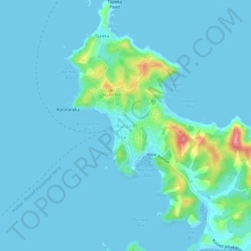
Name: Topografische Karte Russell, Höhe, Relief.
Durchschnittliche Höhe: 12 m
Minimale Höhe: -1 m
Maximale Höhe: 110 m
Andere topografische Karten
Klicken Sie auf eine Karte, um ihre Topografie, ihre Höhe und ihr Relief anzuzeigen.
Onewhero Bay
New Zealand > Northland > Far North District > Bay of Islands-Whangaroa Community
Onewhero Bay, Bay of Islands-Whangaroa Community, Far North District, Northland, 0204, New Zealand
Durchschnittliche Höhe: 18 m
Kerikeri
New Zealand > Northland > Far North District > Bay of Islands-Whangaroa Community
Kerikeri, Bay of Islands-Whangaroa Community, Far North District, Northland, 0230, New Zealand
Durchschnittliche Höhe: 76 m