
Vielen Dank für die Unterstützung dieser Website ❤️
Spenden
Spenden
Topografische Karte Ouarzazate
Klicken Sie auf die Karte, um die Höhe anzuzeigen.
Vielen Dank für die Unterstützung dieser Website ❤️
Spenden
Spenden
Ouarzazate
Ouarzazate (/ˌwɑːrzəˈzæt, -ˈzɑːt/; Arabic: ورزازات, romanized: Warzāzāt, IPA: [warzaːˈzaːt]; Moroccan Arabic: وارزازات, romanized: Wārzāzāt; Berber: ⵡⴰⵔⵣⴰⵣⴰⵜ, romanized: Warzazat), nicknamed the door of the desert, is a city and capital of Ouarzazate Province in the region of Drâa-Tafilalet, south-central Morocco. Ouarzazate is at an elevation of 1,160 metres (3,810 ft) in the middle of a bare plateau south of the High Atlas Mountains, with a desert to the city's south.
Vielen Dank für die Unterstützung dieser Website ❤️
Spenden
Spenden
Über diese Karte
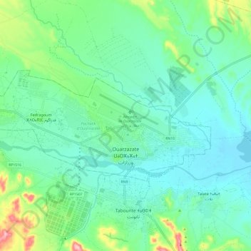
Name: Topografische Karte Ouarzazate, Höhe, Relief.
Durchschnittliche Höhe: 1.144 m
Minimale Höhe: 1.101 m
Maximale Höhe: 1.289 m
Vielen Dank für die Unterstützung dieser Website ❤️
Spenden
Spenden