
Topografische Karte Lago Vista
Klicken Sie auf die Karte, um die Höhe anzuzeigen.
Lago Vista
According to the United States Census Bureau, the city has a total area of 15.52 sq mi (40.2 km2) of which 14.6 sq mi (38 km2) is land and 0.6 sq mi (1.6 km2) (3.95%) is water. The peninsular city sits adjacent to, and partially within, the Balcones Canyonlands. Lago Vista has rugged terrain with elevations ranging from 774 ft (236 m) above sea level at the lake shore to 1220 ft (372 m) above sea level near Rusty Allen Airport. The area is characterized by steep limestone hills and canyons, some of the highest in Travis County.
Über diese Karte
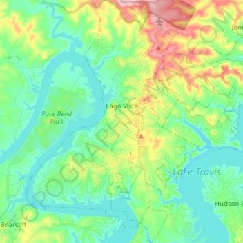
Name: Topografische Karte Lago Vista, Höhe, Relief.
Ort: Lago Vista, Travis County, Texas, United States (30.39919 -98.03744 30.50717 -97.95484)
Durchschnittliche Höhe: 251 m
Minimale Höhe: 196 m
Maximale Höhe: 388 m
Andere topografische Karten
Klicken Sie auf eine Karte, um ihre Topografie, ihre Höhe und ihr Relief anzuzeigen.
McKinney Falls State Park
United States > Texas > Travis County > Austin
Durchschnittliche Höhe: 171 m
Roy G. Guerrero Colorado River Metro Park
United States > Texas > Travis County > Austin
Durchschnittliche Höhe: 141 m
East Boggy Creek Greenbelt
United States > Texas > Travis County > Austin
Durchschnittliche Höhe: 144 m
Austin
United States > Texas > Travis County > Austin
The elevation of Austin varies from 425 feet (130 m) to approximately 1,000 feet (305 m) above sea level. Due to the fact it straddles the Balcones Fault, much of the eastern part of the city is flat, with heavy clay and loam soils, whereas the western part and western suburbs consist of rolling hills on the…
Durchschnittliche Höhe: 203 m
McKinney Falls State Park
United States > Texas > Travis County > Austin
Durchschnittliche Höhe: 171 m
Pflugerville
United States > Texas > Travis County > Pflugerville > Pflugerville
Durchschnittliche Höhe: 219 m