
Topografische Karte Machias
Interaktive Karte
Klicken Sie auf die Karte, um die Höhe anzuzeigen.
Über diese Karte
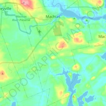
Name: Topografische Karte Machias, Höhe, Relief.
Ort: Machias, Washington County, Maine, 04654, United States (44.64045 -67.50686 44.72920 -67.41543)
Durchschnittliche Höhe: 25 m
Minimale Höhe: -3 m
Maximale Höhe: 103 m
Andere topografische Karten
Klicken Sie auf eine Karte, um ihre Topografie, ihre Höhe und ihr Relief anzuzeigen.
Shag Island
United States > Maine > Washington County > Harrington
Shag Island, Harrington, Washington County, Maine, United States
Durchschnittliche Höhe: 29 m
Slate Island
United States > Maine > Washington County > Beals
Slate Island, Beals, Washington County, Maine, United States
Durchschnittliche Höhe: 4 m
Black Head
United States > Maine > Washington County > Roque Bluffs
Black Head, Roque Bluffs, Washington County, Maine, United States
Durchschnittliche Höhe: 7 m
Red Head
United States > Maine > Washington County > Beals
Red Head, Beals, Washington County, Maine, United States
Durchschnittliche Höhe: 3 m
Nightcap
United States > Maine > Washington County > Addison
Nightcap, Addison, Washington County, Maine, United States
Durchschnittliche Höhe: 0 m