
Spenden
Topografische Karte Hillside
Klicken Sie auf die Karte, um die Höhe anzuzeigen.
Spenden
Über diese Karte
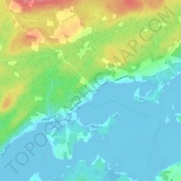
Name: Topografische Karte Hillside, Höhe, Relief.
Durchschnittliche Höhe: 26 m
Minimale Höhe: -3 m
Maximale Höhe: 85 m
Spenden
Andere topografische Karten
Klicken Sie auf eine Karte, um ihre Topografie, ihre Höhe und ihr Relief anzuzeigen.
Hillside Boularderie
Canada > Nova Scotia > Cape Breton Regional Municipality
Durchschnittliche Höhe: 35 m
Spenden
Spenden
Sydney
Canada > Nova Scotia > Cape Breton Regional Municipality
Sydney is on the east bank of the Sydney River where it discharges into South Arm of Sydney Harbour. Elevation ranges from sea level to 66 m (217 ft) above sea level.
Durchschnittliche Höhe: 30 m
Spenden
Spenden
Grand Mira North
Canada > Nova Scotia > Cape Breton Regional Municipality
Durchschnittliche Höhe: 51 m
Spenden
Spenden
Boularderie Island
Canada > Nova Scotia > Cape Breton Regional Municipality > Southside Boularderie
Durchschnittliche Höhe: 75 m
Spenden
Brown Islands
Canada > Nova Scotia > Cape Breton Regional Municipality > Main-à-Dieu
Durchschnittliche Höhe: 0 m
Spenden
Spenden
Mill Creek
Canada > Nova Scotia > Cape Breton Regional Municipality > Mill Creek
Durchschnittliche Höhe: 26 m
Spenden
Sydney
Canada > Nova Scotia > Cape Breton Regional Municipality
Sydney is on the east bank of the Sydney River where it discharges into South Arm of Sydney Harbour. Elevation ranges from sea level to 66 m (217 ft) above sea level.
Durchschnittliche Höhe: 30 m
Spenden
Spenden
Sydney
Canada > Nova Scotia > Cape Breton Regional Municipality
Sydney is on the east bank of the Sydney River where it discharges into South Arm of Sydney Harbour. Elevation ranges from sea level to 66 m (217 ft) above sea level.
Durchschnittliche Höhe: 30 m