
Topografische Karte Warlingham
Klicken Sie auf die Karte, um die Höhe anzuzeigen.
Warlingham
Elevations vary from 110m AOD at Woldingham Road, at the southernmost point of the parish, with a gentle increase in height through the village along the main road heading to the southeast, to the highest elevation (199.6m) at Limpsfield Road.
Über diese Karte
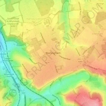
Name: Topografische Karte Warlingham, Höhe, Relief.
Durchschnittliche Höhe: 163 m
Minimale Höhe: 90 m
Maximale Höhe: 224 m
Andere topografische Karten
Klicken Sie auf eine Karte, um ihre Topografie, ihre Höhe und ihr Relief anzuzeigen.
Caterham
United Kingdom > England > Surrey > Tandridge District
In 1840 Caterham contained a total of 477 residents (figures taken from that census, compiled in an 1848 topographical encyclopedia) and in 1848 468 acres (189 ha) of its 2,386 acres (966 ha) were common land. Similar to today, 175 acres (71 ha) mostly steeper acres were woodland.
Durchschnittliche Höhe: 157 m