Topografische Karte Granbury
Interaktive Karte
Klicken Sie auf die Karte, um die Höhe anzuzeigen.
Über diese Karte
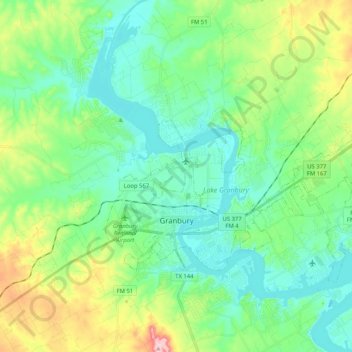
Name: Topografische Karte Granbury, Höhe, Relief.
Ort: Granbury, Hood County, Texas, 76048, United States (32.41132 -97.83436 32.49073 -97.68193)
Durchschnittliche Höhe: 242 m
Minimale Höhe: 210 m
Maximale Höhe: 368 m
Andere topografische Karten
Klicken Sie auf eine Karte, um ihre Topografie, ihre Höhe und ihr Relief anzuzeigen.
Pecan Plantation
United States > Texas > Hood County
Pecan Plantation, Hood County, Texas, United States
Durchschnittliche Höhe: 214 m
Paluxy
United States > Texas > Hood County
Paluxy, Hood County, Texas, United States
Durchschnittliche Höhe: 254 m
Tolar
United States > Texas > Hood County
Tolar, Hood County, Texas, United States
Durchschnittliche Höhe: 317 m
Acton
United States > Texas > Hood County
Acton, Hood County, Texas, 76049, United States
Durchschnittliche Höhe: 243 m
Lipan
United States > Texas > Hood County
Lipan, Hood County, Texas, United States
Durchschnittliche Höhe: 281 m
Brazos Bend
United States > Texas > Hood County
Brazos Bend, Hood County, Texas, United States
Durchschnittliche Höhe: 227 m
DeCordova
United States > Texas > Hood County
DeCordova, Hood County, Texas, United States
Durchschnittliche Höhe: 224 m
Cresson
United States > Texas > Hood County
Cresson, Hood County, Texas, United States
Durchschnittliche Höhe: 303 m
Oak Trail Shores
United States > Texas > Hood County
Oak Trail Shores, Hood County, Texas, United States
Durchschnittliche Höhe: 231 m