
Topografische Karte Potchefstroom
Interaktive Karte
Klicken Sie auf die Karte, um die Höhe anzuzeigen.
Über diese Karte
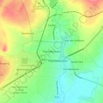
Name: Topografische Karte Potchefstroom, Höhe, Relief.
Durchschnittliche Höhe: 1.350 m
Minimale Höhe: 1.319 m
Maximale Höhe: 1.396 m
Potchefstroom has hosted two World Cup-winning teams (in cricket and football), and is a home away from home for international athletes and teams. At 1,400 metres (4,600 ft) altitude, it provides a good balance between altitude and quality training. The city has no large factories, and good air quality. Athletes and professional teams train at the North-West University's High Performance Institute of Sport.
Andere topografische Karten
Klicken Sie auf eine Karte, um ihre Topografie, ihre Höhe und ihr Relief anzuzeigen.
Boskop Dam
South Africa > North West > Dr Kenneth Kaunda District Municipality > Tlokwe Local Municipality > Boskop
Boskop Dam, Tlokwe Ward 3, Boskop, Tlokwe Local Municipality, Dr Kenneth Kaunda District Municipality, North West, South Africa
Durchschnittliche Höhe: 1.399 m