
Topografische Karte Totonicapán
Interaktive Karte
Klicken Sie auf die Karte, um die Höhe anzuzeigen.
Über diese Karte
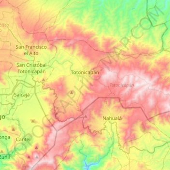
Name: Topografische Karte Totonicapán, Höhe, Relief.
Ort: Totonicapán, 08001, Guatemala (14.82348 -91.43775 14.96111 -91.17532)
Durchschnittliche Höhe: 2.583 m
Minimale Höhe: 1.817 m
Maximale Höhe: 3.373 m
Andere topografische Karten
Klicken Sie auf eine Karte, um ihre Topografie, ihre Höhe und ihr Relief anzuzeigen.
Santa Lucía la Reforma
Guatemala > Totonicapán > Santa Lucía La Reforma
Santa Lucía la Reforma, Santa Lucía La Reforma, Totonicapán, Guatemala
Durchschnittliche Höhe: 1.860 m
San Bartolo
San Bartolo, Totonicapán, Guatemala
Durchschnittliche Höhe: 2.136 m
Momostenango
Momostenango, Totonicapán, Guatemala
Durchschnittliche Höhe: 2.003 m
San Cristóbal Totonicapán
San Cristóbal Totonicapán, Totonicapán, Guatemala
Durchschnittliche Höhe: 2.561 m
San Andrés Xecul
San Andrés Xecul, Totonicapán, Guatemala
Durchschnittliche Höhe: 2.586 m
San Francisco El Alto
San Francisco El Alto, Totonicapán, Guatemala
Durchschnittliche Höhe: 2.671 m
Santa Lucía La Reforma
Santa Lucía La Reforma, Totonicapán, Guatemala
Durchschnittliche Höhe: 1.808 m