
Topografische Karte Sawantwadi
Interaktive Karte
Klicken Sie auf die Karte, um die Höhe anzuzeigen.
Über diese Karte
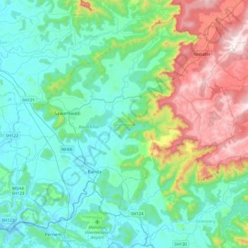
Name: Topografische Karte Sawantwadi, Höhe, Relief.
Ort: Sawantwadi, Sindhudurg, Maharashtra, India (15.72107 73.68912 16.05990 74.09510)
Durchschnittliche Höhe: 251 m
Minimale Höhe: -1 m
Maximale Höhe: 1.030 m
Andere topografische Karten
Klicken Sie auf eine Karte, um ihre Topografie, ihre Höhe und ihr Relief anzuzeigen.
Palghar
India > Maharashtra > Palghar Taluka
Palghar, Palghar Taluka, Palghar District, Maharashtra, 401400, India
Durchschnittliche Höhe: 19 m
Gahunje
India > Maharashtra > Mawal
Gahunje, Mawal, Pune District, Maharashtra, 412101, India
Durchschnittliche Höhe: 584 m
Udgir
Udgir, Latur District, Maharashtra, 413517, India
Durchschnittliche Höhe: 563 m
Achalpur
Achalpur, Amravati District, Maharashtra, India
Durchschnittliche Höhe: 451 m
Yavatmal District
Yavatmal District, Maharashtra, India
Durchschnittliche Höhe: 328 m
Amravati
Amravati, Amravati District, Maharashtra, India
Durchschnittliche Höhe: 349 m
Kulgaon Badlapur
India > Maharashtra > Ambernath Taluka
Kulgaon Badlapur, Ambernath Taluka, Thane District, Maharashtra, 421503, India
Durchschnittliche Höhe: 57 m
Indian subcontinent
India > Maharashtra > Arni
Indian subcontinent, Arni, Yavatmal, Maharashtra, India
Durchschnittliche Höhe: 352 m
Yavatmal
Yavatmal, Yavatmal District, Maharashtra, 445300, India
Durchschnittliche Höhe: 308 m
Hinganghat
Hinganghat, Wardha District, Maharashtra, India
Durchschnittliche Höhe: 233 m
Patan
India > Maharashtra > Patan
Patan, Satara District, Maharashtra, 415206, India
Durchschnittliche Höhe: 668 m
Gairan Wasti
India > Maharashtra > Dharashiv > Waruda
Gairan Wasti, Waruda, Dharashiv, Dharashiv District, Maharashtra, India
Durchschnittliche Höhe: 663 m
Digdoh
India > Maharashtra > Nagpur Urban Taluka
Digdoh, Nagpur Urban Taluka, Nagpur District, Maharashtra, 440019, India
Durchschnittliche Höhe: 326 m
Wawana
India > Maharashtra > Phulambri
Wawana, Phulambri, Chhatrapati Sambhajinagar District, Maharashtra, India
Durchschnittliche Höhe: 681 m
Nipani
India > Maharashtra > Chhatrapati Sambhajinagar
Nipani, Chhatrapati Sambhajinagar, Chhatrapati Sambhajinagar District, Maharashtra, 431007, India
Durchschnittliche Höhe: 560 m
Chatri Nizampur
India > Maharashtra > Mahad
Chatri Nizampur, Mahad, Raigad District, Maharashtra, 402104, India
Durchschnittliche Höhe: 330 m
Panchgani
India > Maharashtra > Mahabaleshwar
Panchgani, Mahabaleshwar, Satara, Maharashtra, 412805, India
Durchschnittliche Höhe: 1.019 m
Kurunji
India > Maharashtra > Bhor
Kurunji, Bhor, Pune, Maharashtra, India
Durchschnittliche Höhe: 712 m
Gaganbavda
India > Maharashtra > Gaganbavda
Gaganbavda, Kolhapur, Maharashtra, 416006, India
Durchschnittliche Höhe: 469 m
Moula Ali
India > Maharashtra > Mukhed > Manjari
Moula Ali, Manjari, Mukhed, Nanded, Maharashtra, India
Durchschnittliche Höhe: 453 m
Sarud
India > Maharashtra > Shahuwadi
Sarud, Shahuwadi, Kolhapur, Maharashtra, 416213, India
Durchschnittliche Höhe: 565 m
Georai
India > Maharashtra > Georai
Georai, Beed, Maharashtra, 431127, India
Durchschnittliche Höhe: 464 m
Ratanpur
India > Maharashtra > Chandurbazar
Ratanpur, Chandurbazar, Amravati, Maharashtra, India
Durchschnittliche Höhe: 408 m
Sondri
India > Maharashtra > Brahmapuri Taluka
Sondri, Brahmapuri Taluka, Chandrapur, Maharashtra, India
Durchschnittliche Höhe: 222 m
Bramhanwada Pathak
India > Maharashtra > Chandurbazar
Bramhanwada Pathak, Chandurbazar, Amravati, Maharashtra, India
Durchschnittliche Höhe: 392 m
Paraswada
India > Maharashtra > Tumsar Taluka
Paraswada, Tumsar Taluka, Bhandara, Maharashtra, India
Durchschnittliche Höhe: 272 m
Ratnagiri
India > Maharashtra > Ratnagiri
Ratnagiri, Maharashtra, 415612, India
Durchschnittliche Höhe: 30 m
Gardewada
India > Maharashtra > Etapalli
Gardewada, Etapalli, Gadchiroli, Maharashtra, India
Durchschnittliche Höhe: 271 m
Hotagi
India > Maharashtra > Solapur South
Hotagi, Solapur South, Solapur, Maharashtra, India
Durchschnittliche Höhe: 459 m
Umbraj
India > Maharashtra > Karad
Umbraj, Karad, Satara, Maharashtra, 415109, India
Durchschnittliche Höhe: 594 m
Kotha
India > Maharashtra > Dharni
Kotha, Dharni, Amravati, Maharashtra, India
Durchschnittliche Höhe: 409 m
अमरावती
अमरावती, Amravati, Maharashtra, 444801, India
Durchschnittliche Höhe: 421 m
Medha
India > Maharashtra > Bhiwapur Taluka
Medha, Bhiwapur Taluka, Nagpur, Maharashtra, India
Durchschnittliche Höhe: 265 m
Konsari
India > Maharashtra > Chamorshi
Konsari, Chamorshi, Gadchiroli, Maharashtra, India
Durchschnittliche Höhe: 173 m
Raigad
India > Maharashtra > Mahad > Hirkaniwadi
Raigad, Hirkaniwadi, Mahad, Raigad, Maharashtra, 402104, India
Durchschnittliche Höhe: 454 m
Ratangad
India > Maharashtra > Akola > Samrad
Ratangad, Katrabai to Ratangad, Samrad, Akola, Ahmednagar, Maharashtra, India
Durchschnittliche Höhe: 872 m
Ghosala
India > Maharashtra > Soegaon
Ghosala, Soegaon, Chhatrapati Sambhajinagar, Maharashtra, India
Durchschnittliche Höhe: 352 m