Topografische Karte Castle Valley
Interaktive Karte
Klicken Sie auf die Karte, um die Höhe anzuzeigen.
Über diese Karte
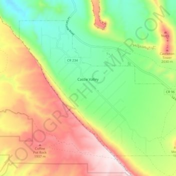
Name: Topografische Karte Castle Valley, Höhe, Relief.
Ort: Castle Valley, Grand County, Utah, United States (38.60833 -109.44475 38.66322 -109.35336)
Durchschnittliche Höhe: 1.610 m
Minimale Höhe: 1.265 m
Maximale Höhe: 2.067 m
Andere topografische Karten
Klicken Sie auf eine Karte, um ihre Topografie, ihre Höhe und ihr Relief anzuzeigen.
Moab
United States > Utah > Grand County
Moab, Grand County, Utah, 84532, United States
Durchschnittliche Höhe: 1.357 m
Manns Peak
United States > Utah > Grand County
Manns Peak, Grand County, Utah, United States
Durchschnittliche Höhe: 3.427 m
Castleton Tower
United States > Utah > Grand County
Castleton Tower, Grand County, Utah, United States
Durchschnittliche Höhe: 1.549 m
Arches National Park
United States > Utah > Grand County
Arches National Park, Grand County, Utah, United States
Durchschnittliche Höhe: 1.476 m