
Topografische Karte Craters of the Moon
Interaktive Karte
Klicken Sie auf die Karte, um die Höhe anzuzeigen.
Über diese Karte
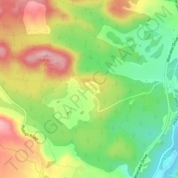
Name: Topografische Karte Craters of the Moon, Höhe, Relief.
Durchschnittliche Höhe: 441 m
Minimale Höhe: 352 m
Maximale Höhe: 543 m
Craters of the Moon is a steam field with a total of about 36 hectares (0.36 km2) of heated ground. It has an average altitude of 435 m. It has – of course – craters, but it also has fumaroles (“blowholes”) and a mudpool. Vegetation around the area of the Craters of the Moon is quite uncommon.
Andere topografische Karten
Klicken Sie auf eine Karte, um ihre Topografie, ihre Höhe und ihr Relief anzuzeigen.
Tokaanu
New Zealand > Waikato > Taupo District
Tokaanu, Taupō District, Waikato, New Zealand
Durchschnittliche Höhe: 409 m
Pokuru
New Zealand > Waikato > Taupo District
Pokuru, Taupo District, Waikato, New Zealand
Durchschnittliche Höhe: 510 m
Wairakei Village
New Zealand > Waikato > Taupo District
Wairakei Village, Taupo District, Waikato, New Zealand
Durchschnittliche Höhe: 407 m
Turangi
New Zealand > Waikato > Taupo District
Turangi, Taupo District, Waikato, 3334, New Zealand
Durchschnittliche Höhe: 417 m