
Topografische Karte Cumbre
Interaktive Karte
Klicken Sie auf die Karte, um die Höhe anzuzeigen.
Über diese Karte
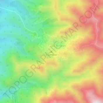
Name: Topografische Karte Cumbre, Höhe, Relief.
Durchschnittliche Höhe: 1.368 m
Minimale Höhe: 1.097 m
Maximale Höhe: 1.690 m
Andere topografische Karten
Klicken Sie auf eine Karte, um ihre Topografie, ihre Höhe und ihr Relief anzuzeigen.
Municipio de La Cumbre
Argentina > Córdoba > Pedanía Dolores
Municipio de La Cumbre, Pedanía Dolores, Departamento Punilla, Córdoba, X5166, Argentina
Durchschnittliche Höhe: 1.274 m
Río Seco
Argentina > Córdoba > Pedanía Dolores > Santa Isabel
Río Seco, Santa Isabel, Comuna de Charbonier, Pedanía Dolores, Departamento Punilla, Córdoba, 5282, Argentina
Durchschnittliche Höhe: 1.180 m
Capilla del Monte
Argentina > Córdoba > Pedanía Dolores
Capilla del Monte, Municipio de Capilla del Monte, Pedanía Dolores, Departamento Punilla, Córdoba, X5166, Argentina
Durchschnittliche Höhe: 1.016 m