
Topografische Karte Neerim South
Klicken Sie auf die Karte, um die Höhe anzuzeigen.
Über diese Karte
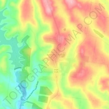
Name: Topografische Karte Neerim South, Höhe, Relief.
Ort: Neerim South, Shire of Baw Baw, Victoria, 3831, Australia (-38.03568 145.93380 -37.99568 145.97380)
Durchschnittliche Höhe: 215 m
Minimale Höhe: 122 m
Maximale Höhe: 299 m
Andere topografische Karten
Klicken Sie auf eine Karte, um ihre Topografie, ihre Höhe und ihr Relief anzuzeigen.
City of Melbourne
Melbourne's topography is characterized by a diverse landscape that transitions from flat coastal plains to rolling hills and mountainous regions. The city is situated at the northern end of Port Phillip Bay, where the terrain is predominantly flat, facilitating urban development. As one moves eastward, the…
Durchschnittliche Höhe: 18 m
Australian Garden - Royal Botanic Gardens Cranbourne
Australia > Victoria > Melbourne
Durchschnittliche Höhe: 70 m