
Spenden
Topografische Karte Itu
Klicken Sie auf die Karte, um die Höhe anzuzeigen.
Spenden
Itu
Itu is a historic city and municipality in the state of São Paulo in Brazil. It is part of the Metropolitan Region of Sorocaba. The population was 175,568 as of 2020, in an area of 640.72 km2. The elevation is 583 m. This place name comes from the Tupi language, meaning big waterfall. Two rivers flow through Itu: Tietê and Jundiaí. Itu has five hospitals, eleven bank agencies and one shopping center, the Plaza Shopping Itu.
Spenden
Über diese Karte
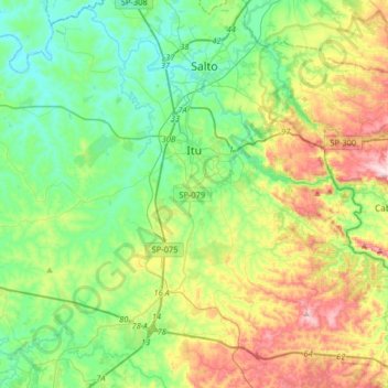
Name: Topografische Karte Itu, Höhe, Relief.
Durchschnittliche Höhe: 630 m
Minimale Höhe: 489 m
Maximale Höhe: 942 m
Spenden
Andere topografische Karten
Klicken Sie auf eine Karte, um ihre Topografie, ihre Höhe und ihr Relief anzuzeigen.
Sorocaba
Brazil > São Paulo > Região Metropolitana de Sorocaba > Sorocaba
The terrain is classified as a wavy strands and characterized by local ridges, with an average altitude of 632 meters above the sea level. The highest altitude is 1028 meters, in the Serra de Sao Francisco. The lower altitude is 539 meters, in the valley of the Sorocaba River. Sorocaba is located on the edge…
Durchschnittliche Höhe: 662 m