Spenden
Topografische Karte Southern Harbour
Klicken Sie auf die Karte, um die Höhe anzuzeigen.
Spenden
Über diese Karte
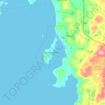
Name: Topografische Karte Southern Harbour, Höhe, Relief.
Durchschnittliche Höhe: 35 m
Minimale Höhe: 0 m
Maximale Höhe: 205 m
Spenden
Andere topografische Karten
Klicken Sie auf eine Karte, um ihre Topografie, ihre Höhe und ihr Relief anzuzeigen.
Spenden
Spenden
Spenden
Bell Island
Canada > Newfoundland and Labrador > Wabana
The coast is very rocky and consists almost entirely of steep cliffs tens of meters high that tower up to 45 kilometres (28 mi) above sea level. The island, which continues to gain in altitude especially close to the coastline, reaches a maximum height of 148 metres (486 ft). Because the central part of the…
Durchschnittliche Höhe: 30 m
Terra Nova National Park
Canada > Newfoundland and Labrador
Terra Nova's landscape is typical of the northeast coast of Newfoundland, but with remnants of the Appalachian Mountains contributing to widely varied and rugged topography throughout the region. The park's seacoast consists of several rocky "fingers" jutting into Bonavista Bay along an area stretching from…
Durchschnittliche Höhe: 58 m
Spenden
Spenden
Spenden
Spenden
Spenden
Spenden
Spenden
Spenden
Spenden
Spenden
Spenden
Clarenville
Canada > Newfoundland and Labrador
The Clarenville area has many of the physical features characteristic of the East Coast of Newfoundland and has a marine climate. It lies along the coastal slopes which rise from the Atlantic Ocean towards the interior central plateau of the island. The dominating physical feature is a ridge of broken peaks…
Durchschnittliche Höhe: 102 m
Spenden
Spenden
Spenden
Spenden
Spenden
Spenden
Spenden
Spenden
Spenden
Spenden
Spenden
