
Topografische Karte Hamilton
Interaktive Karte
Klicken Sie auf die Karte, um die Höhe anzuzeigen.
Über diese Karte
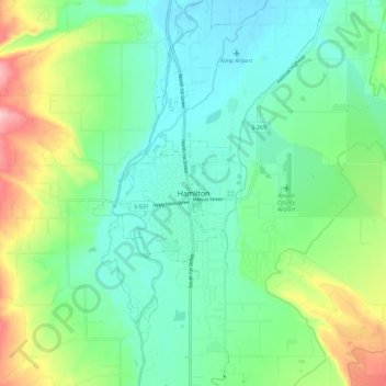
Name: Topografische Karte Hamilton, Höhe, Relief.
Ort: Hamilton, Ravalli County, Montana, 59840, United States (46.20889 -114.19433 46.28889 -114.11433)
Durchschnittliche Höhe: 1.115 m
Minimale Höhe: 1.065 m
Maximale Höhe: 1.240 m
Andere topografische Karten
Klicken Sie auf eine Karte, um ihre Topografie, ihre Höhe und ihr Relief anzuzeigen.
Hamilton
United States > Montana > Ravalli County
Hamilton, Ravalli County, Montana, United States
Durchschnittliche Höhe: 1.097 m
Victor
United States > Montana > Ravalli County
Victor, Ravalli County, Montana, United States
Durchschnittliche Höhe: 1.047 m
Stevensville
United States > Montana > Ravalli County
Stevensville, Ravalli County, Montana, United States
Durchschnittliche Höhe: 1.013 m
Mill Point
United States > Montana > Ravalli County
Mill Point, Ravalli County, Montana, United States
Durchschnittliche Höhe: 2.129 m
Darby
United States > Montana > Ravalli County
Darby, Ravalli County, Montana, United States
Durchschnittliche Höhe: 1.210 m
Downing Mountain
United States > Montana > Ravalli County
Downing Mountain, Ravalli County, Montana, United States
Durchschnittliche Höhe: 2.208 m
Corvallis
United States > Montana > Ravalli County > Corvallis
Corvallis, Ravalli County, Montana, United States
Durchschnittliche Höhe: 1.060 m