
Topografische Karte Kansas City
Interaktive Karte
Klicken Sie auf die Karte, um die Höhe anzuzeigen.
Über diese Karte
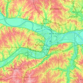
Name: Topografische Karte Kansas City, Höhe, Relief.
Ort: Kansas City, Wyandotte County, Kansas, United States (39.04357 -94.90842 39.20291 -94.58820)
Durchschnittliche Höhe: 268 m
Minimale Höhe: 217 m
Maximale Höhe: 333 m
Andere topografische Karten
Klicken Sie auf eine Karte, um ihre Topografie, ihre Höhe und ihr Relief anzuzeigen.
Wallula
United States > Kansas > Wyandotte County > Kansas City
Wallula, Kansas City, Wyandotte County, Kansas, United States
Durchschnittliche Höhe: 292 m
Wyandotte County Lake
United States > Kansas > Wyandotte County > Kansas City > Vinewood
Wyandotte County Lake, Vinewood, Kansas City, Wyandotte County, Kansas, United States
Durchschnittliche Höhe: 271 m
Edwardsville
United States > Kansas > Wyandotte County
Edwardsville, Wyandotte County, Kansas, 66113, United States
Durchschnittliche Höhe: 265 m
Bonner Springs
United States > Kansas > Wyandotte County
Bonner Springs, Wyandotte County, Kansas, 66012, United States
Durchschnittliche Höhe: 273 m
Morris
United States > Kansas > Wyandotte County > Kansas City > Morris
Morris, Kansas City, Wyandotte County, Kansas, 66111, United States
Durchschnittliche Höhe: 253 m