
Spenden
Topografische Karte Rileyville
Klicken Sie auf die Karte, um die Höhe anzuzeigen.
Spenden
Über diese Karte
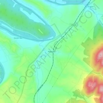
Name: Topografische Karte Rileyville, Höhe, Relief.
Ort: Rileyville, Page County, Virginia, 22650, United States (38.74441 -78.40756 38.78441 -78.36756)
Durchschnittliche Höhe: 244 m
Minimale Höhe: 179 m
Maximale Höhe: 396 m
Spenden
Andere topografische Karten
Klicken Sie auf eine Karte, um ihre Topografie, ihre Höhe und ihr Relief anzuzeigen.
Shenandoah National Park
United States > Virginia > Page County
Shenandoah National Park lies along the Blue Ridge Mountains in north-central Virginia. These mountains form a distinct highland rising to elevations above 4,000 feet (1,200 m). Local topographic relief between the Blue Ridge Mountains and Shenandoah Valley exceeds 3,000 feet (910 m) at some locations. The…
Durchschnittliche Höhe: 335 m
Spenden
Shenandoah National Park
United States > Virginia > Page County
Shenandoah National Park lies along the Blue Ridge Mountains in north-central Virginia. These mountains form a distinct highland rising to elevations above 4,000 feet (1,200 m). Local topographic relief between the Blue Ridge Mountains and Shenandoah Valley exceeds 3,000 feet (900 m) at some locations. The…
Durchschnittliche Höhe: 335 m
Spenden