
Topografische Karte Euxton
Klicken Sie auf die Karte, um die Höhe anzuzeigen.
Über diese Karte
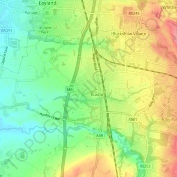
Name: Topografische Karte Euxton, Höhe, Relief.
Ort: Euxton, Chorley, Lancashire, England, United Kingdom (53.65252 -2.72081 53.68191 -2.63997)
Durchschnittliche Höhe: 50 m
Minimale Höhe: 16 m
Maximale Höhe: 97 m
Andere topografische Karten
Klicken Sie auf eine Karte, um ihre Topografie, ihre Höhe und ihr Relief anzuzeigen.
Coppull
United Kingdom > England > Lancashire > Chorley
The settlement has an Anglo Saxon name describing its topography derived from the Old English copp a hill top and hyll a hill. The township was variously recorded as Cophull and Cophulle in 1277, Copphull in 1351, Copthull in 1374 and Coppull from 1444.
Durchschnittliche Höhe: 79 m