
Spenden
Topografische Karte Spences Bridge
Klicken Sie auf die Karte, um die Höhe anzuzeigen.
Spenden
Spences Bridge
Spences Bridge's location is mountainous, with higher elevations part of the Interior Plateau. The east side of the Fraser here is part of the Clear Range, a mountainous southwards extension of the Fraser Plateau located in the angle of the Thompson and Fraser Rivers. Arthur Seat lies in that range on the west side of Spences Bridge, and was named by pioneer John Murray for Arthur's Seat in Edinburgh, Scotland.
Spenden
Über diese Karte
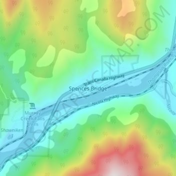
Name: Topografische Karte Spences Bridge, Höhe, Relief.
Durchschnittliche Höhe: 495 m
Minimale Höhe: 213 m
Maximale Höhe: 1.195 m
Spenden
Andere topografische Karten
Klicken Sie auf eine Karte, um ihre Topografie, ihre Höhe und ihr Relief anzuzeigen.
Blue Earth Lake Provincial Park
Canada > British Columbia > Thompson-Nicola Regional District > Area I (Blue Sky Country)
Durchschnittliche Höhe: 1.540 m