
Topografische Karte Red Wing
Interaktive Karte
Klicken Sie auf die Karte, um die Höhe anzuzeigen.
Über diese Karte
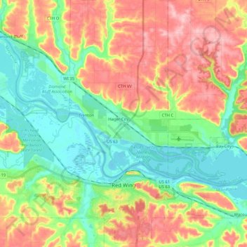
Name: Topografische Karte Red Wing, Höhe, Relief.
Ort: Red Wing, Goodhue County, Minnesota, United States (44.52796 -92.67277 44.66966 -92.46723)
Durchschnittliche Höhe: 263 m
Minimale Höhe: 199 m
Maximale Höhe: 353 m
According to the United States Census Bureau, the city has an area of 41.19 square miles (106.68 km2), of which 34.60 square miles (89.61 km2) is land and 6.59 square miles (17.07 km2) is water. The city is at the northern edge of the Driftless Area of karst topography.
Andere topografische Karten
Klicken Sie auf eine Karte, um ihre Topografie, ihre Höhe und ihr Relief anzuzeigen.
Zumbrota
United States > Minnesota > Goodhue County
Zumbrota, Goodhue County, Minnesota, 55992, United States
Durchschnittliche Höhe: 312 m
Kenyon
United States > Minnesota > Goodhue County
Kenyon, Goodhue County, Minnesota, United States
Durchschnittliche Höhe: 351 m
Dennison
United States > Minnesota > Goodhue County
Dennison, Goodhue County, Minnesota, United States
Durchschnittliche Höhe: 303 m
Frontenac
United States > Minnesota > Goodhue County
Frontenac, Florence Township, Goodhue County, Minnesota, 55026, United States
Durchschnittliche Höhe: 243 m
Goodhue
United States > Minnesota > Goodhue County
Goodhue, Goodhue County, Minnesota, 55027, United States
Durchschnittliche Höhe: 346 m
Wanamingo
United States > Minnesota > Goodhue County
Wanamingo, Goodhue County, Minnesota, 55983, United States
Durchschnittliche Höhe: 325 m
Pine Island
United States > Minnesota > Goodhue County
Pine Island, Goodhue County, Minnesota, United States
Durchschnittliche Höhe: 327 m
Welch
United States > Minnesota > Goodhue County
Welch, Welch Township, Goodhue County, Minnesota, United States
Durchschnittliche Höhe: 277 m
Cannon Falls
United States > Minnesota > Goodhue County > Cannon Falls > Cannon Falls
Cannon Falls, Goodhue County, Minnesota, 55009, United States
Durchschnittliche Höhe: 268 m
Cannon Falls
United States > Minnesota > Goodhue County
Cannon Falls, Goodhue County, Minnesota, 55009, United States
Durchschnittliche Höhe: 276 m