
Spenden
Topografische Karte Pallejà
Klicken Sie auf die Karte, um die Höhe anzuzeigen.
Spenden
Pallejà
Pallejá (Pallejà oficialmente y en catalán) es un municipio de Cataluña, España. Perteneciente a la provincia de Barcelona, está situado en la comarca del Bajo Llobregat y forma parte del área metropolitana de Barcelona. El término municipal tiene una extensión de 8,30 km² (de los cuales el 23% son suelo edificado) y tiene una altitud media de 87 m s. n. m..
Spenden
Über diese Karte
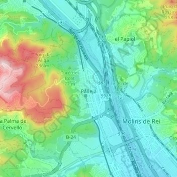
Name: Topografische Karte Pallejà, Höhe, Relief.
Ort: Pallejà, Bajo Llobregat, Barcelona, Cataluña, España (41.40580 1.94464 41.43982 2.00939)
Durchschnittliche Höhe: 97 m
Minimale Höhe: 14 m
Maximale Höhe: 330 m
Spenden
Andere topografische Karten
Klicken Sie auf eine Karte, um ihre Topografie, ihre Höhe und ihr Relief anzuzeigen.
Spenden
Santa Coloma de Cervelló
España > Cataluña > Bajo Llobregat > Santa Coloma de Cervelló > Santa Coloma de Cervelló
Durchschnittliche Höhe: 79 m
Cornellà de Llobregat
España > Cataluña > Bajo Llobregat > Cornellà de Llobregat > Cornellà de Llobregat
El relieve es prácticamente llano, oscilando la altitud entre los 67 metros al norte y los 9 metros a orillas del Llobregat. El casco histórico se alza a 27 metros sobre el nivel del mar.
Durchschnittliche Höhe: 39 m
Esplugues de Llobregat
España > Cataluña > Bajo Llobregat > Esplugues de Llobregat > Esplugues de Llobregat
Durchschnittliche Höhe: 97 m
Spenden
Spenden
Plaza Cataluña
España > Cataluña > Bajo Llobregat > Cornellà de Llobregat
Durchschnittliche Höhe: 35 m
Agulles del Petintó inferior (Espases de Sant Salvador)
España > Cataluña > Bajo Llobregat > Olesa de Montserrat
Durchschnittliche Höhe: 291 m
Spenden
Pou del Merlí
España > Cataluña > Bajo Llobregat > Martorell > Pou del Merlí
Durchschnittliche Höhe: 112 m
Sant Climent de Llobregat
España > Cataluña > Bajo Llobregat > Sant Climent de Llobregat
Durchschnittliche Höhe: 148 m
Spenden