
Topografische Karte Gumaca
Klicken Sie auf die Karte, um die Höhe anzuzeigen.
Über diese Karte
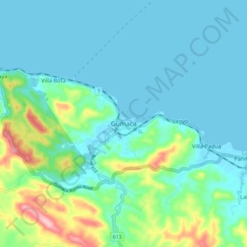
Name: Topografische Karte Gumaca, Höhe, Relief.
Ort: Gumaca, Quezon, Calabarzon, 4306, Philippines (13.88217 122.05913 13.96217 122.13913)
Durchschnittliche Höhe: 34 m
Minimale Höhe: 0 m
Maximale Höhe: 169 m
Andere topografische Karten
Klicken Sie auf eine Karte, um ihre Topografie, ihre Höhe und ihr Relief anzuzeigen.
Sariaya
Sariaya is situated on a flat land except for a portion on the north occupying a part of the foot of Mount Banahaw. The municipality has the highest point of elevation on 3,800 feet above sea level at Barangays Concepcion Banahaw and Sampaloc Bogon.
Durchschnittliche Höhe: 117 m
Padre Burgos
On January 1, 1917, the village of Laguimanoc, which was formerly a barrio of Atimonan, became a municipality of what was then the province of Tayabas. On December 3, 1927, the town's name was changed to Padre Burgos by virtue of Act No. 3389, in honor of one of the country's martyrs, Fr. Jose Burgos. The…
Durchschnittliche Höhe: 20 m
Laguna-Quezon Land Grant Lagoon
Philippines > Quezon > Real > Magsaysay > Maunlad
Durchschnittliche Höhe: 389 m
Sariaya
Sariaya is situated on a flat land except for a portion on the north occupying a part of the foot of Mount Banahaw. The municipality has the highest point of elevation on 3,800 feet (1,200 m) above sea level at Barangays Concepcion Banahaw and Sampaloc Bogon.
Durchschnittliche Höhe: 117 m
Sariaya
Sariaya is situated on a flat land except for a portion on the north occupying a part of the foot of Mount Banahaw. The municipality has the highest point of elevation on 3,800 feet above sea level at Barangays Concepcion Banahaw and Sampaloc Bogon.
Durchschnittliche Höhe: 117 m
Sariaya
Sariaya is situated on a flat land except for a portion on the north occupying a part of the foot of Mount Banahaw. The municipality has the highest point of elevation on 3,800 feet (1,200 m) above sea level at Barangays Concepcion Banahaw and Sampaloc Bogon.
Durchschnittliche Höhe: 117 m
Sariaya
Sariaya is situated on a flat land except for a portion on the north occupying a part of the foot of Mount Banahaw. The municipality has the highest point of elevation on 3,800 feet (1,200 m) above sea level at Barangays Concepcion Banahaw and Sampaloc Bogon.
Durchschnittliche Höhe: 117 m