
Topografische Karte Little Rock
Interaktive Karte
Klicken Sie auf die Karte, um die Höhe anzuzeigen.
Über diese Karte
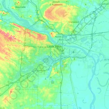
Name: Topografische Karte Little Rock, Höhe, Relief.
Ort: Little Rock, Pulaski County, Arkansas, États-Unis d'Amérique (34.62567 -92.52159 34.82182 -92.15066)
Durchschnittliche Höhe: 96 m
Minimale Höhe: 63 m
Maximale Höhe: 244 m
Andere topografische Karten
Klicken Sie auf eine Karte, um ihre Topografie, ihre Höhe und ihr Relief anzuzeigen.
Pulaski County
États-Unis d'Amérique > Arkansas > Pulaski County
Pulaski County, Arkansas, États-Unis d'Amérique
Durchschnittliche Höhe: 101 m
Little Rock
États-Unis d'Amérique > Arkansas > Pulaski County > Little Rock
Little Rock, Pulaski County, Arkansas, 72201, États-Unis d'Amérique
Durchschnittliche Höhe: 98 m
Sherwood
États-Unis d'Amérique > Arkansas > Pulaski County
Sherwood, Pulaski County, Arkansas, 72120, États-Unis d'Amérique
Durchschnittliche Höhe: 108 m