
Vielen Dank für die Unterstützung dieser Website ❤️
Spenden
Spenden
Topografische Karte Rocky Mountain House
Klicken Sie auf die Karte, um die Höhe anzuzeigen.
Vielen Dank für die Unterstützung dieser Website ❤️
Spenden
Spenden
Rocky Mountain House
Rocky Mountain House has a subarctic climate (Köppen climate classification Dfc) that borders on a humid continental climate (Köppen Dfb). Daytime temperatures are in general representative for the latter, but the larger diurnal temperature variation with the high elevation ensures frequent frosts. The January average high of around −4 °C (25 °F) is actually much milder than clear continental areas further east in Canada on similar and lower parallels.
Vielen Dank für die Unterstützung dieser Website ❤️
Spenden
Spenden
Über diese Karte
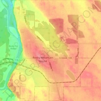
Name: Topografische Karte Rocky Mountain House, Höhe, Relief.
Ort: Rocky Mountain House, Alberta, Canada (52.35580 -114.94816 52.40673 -114.87780)
Durchschnittliche Höhe: 988 m
Minimale Höhe: 941 m
Maximale Höhe: 1.013 m
Vielen Dank für die Unterstützung dieser Website ❤️
Spenden
Spenden