Geolokalisieren
👉 Easily get elevation data in JSON, GeoTIFF and KML formats using Elevation API
Vielen Dank für die Unterstützung dieser Website ❤️
Spenden

Topografische Karte Monte Dolent

Klicken Sie auf die Karte, um die Höhe anzuzeigen.

👉 Easily get elevation data in JSON, GeoTIFF and KML formats using Elevation API
Vielen Dank für die Unterstützung dieser Website ❤️
Spenden

Über diese Karte

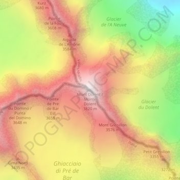
Name: Topografische Karte Monte Dolent, Höhe, Relief.

Ort: Monte Dolent, Courmayeur, Valle d'Aosta, Italia (45.92194 7.04613 45.92204 7.04623)

Durchschnittliche Höhe: 3.110 m

Minimale Höhe: 2.220 m

Maximale Höhe: 3.797 m

👉 Easily get elevation data in JSON, GeoTIFF and KML formats using Elevation API
Vielen Dank für die Unterstützung dieser Website ❤️
Spenden

Andere topografische Karten

Klicken Sie auf eine Karte, um ihre Topografie, ihre Höhe und ihr Relief anzuzeigen.

Ghiacciaio della Brenva

Italia > Valle d'Aosta > Courmayeur

Durchschnittliche Höhe: 3.373 m

Ghiacciaio del Miage

Italia > Valle d'Aosta > Courmayeur

Durchschnittliche Höhe: 2.912 m

Ghiacciaio di Pré de Bar

Italia > Valle d'Aosta > Courmayeur

Durchschnittliche Höhe: 3.078 m

Ghiacciaio di Bionassay

Italia > Valle d'Aosta > Courmayeur

Durchschnittliche Höhe: 3.356 m

Vielen Dank für die Unterstützung dieser Website ❤️
Spenden

Ghiacciaio della Lex Blanche

Italia > Valle d'Aosta > Courmayeur

Durchschnittliche Höhe: 3.132 m