
Topografische Karte Gr. dell'Agnello
Interaktive Karte
Klicken Sie auf die Karte, um die Höhe anzuzeigen.
Über diese Karte
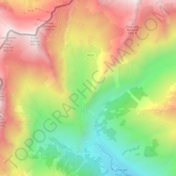
Name: Topografische Karte Gr. dell'Agnello, Höhe, Relief.
Ort: Gr. dell'Agnello, Pontechianale, Coni, Piémont, Italie (44.64524 6.96794 44.68524 7.00794)
Durchschnittliche Höhe: 2.400 m
Minimale Höhe: 1.776 m
Maximale Höhe: 3.021 m
Andere topografische Karten
Klicken Sie auf eine Karte, um ihre Topografie, ihre Höhe und ihr Relief anzuzeigen.
La Chenal
Italie > Piémont > Coni > Pontechianale
La Chenal, Pontechianale, Coni, Piémont, Italie
Durchschnittliche Höhe: 2.223 m
Castello
Italie > Piémont > Coni > Pontechianale
Castello, Pontechianale, Coni, Piémont, Italie
Durchschnittliche Höhe: 1.901 m
Fonte
Italie > Piémont > Coni > Pontechianale
Fonte, Monviso - via normale, Pontechianale, Coni, Piémont, Italie
Durchschnittliche Höhe: 2.690 m
Col Agnel
Italie > Piémont > Coni > Pontechianale
Col Agnel, Pontechianale, Coni, Piémont, Italie
Durchschnittliche Höhe: 2.700 m