Geolokalisieren
👉 Easily get elevation data in JSON, GeoTIFF and KML formats using Elevation API
Vielen Dank für die Unterstützung dieser Website ❤️
Spenden

Topografische Karte Strefford

Klicken Sie auf die Karte, um die Höhe anzuzeigen.

👉 Easily get elevation data in JSON, GeoTIFF and KML formats using Elevation API
Vielen Dank für die Unterstützung dieser Website ❤️
Spenden

Strefford

It lies in the civil parish of Wistanstow and is situated just off the A49 road, 2 miles (3.2 km) north of the small town of Craven Arms. The nearest settlement is Upper Affcot, a hamlet located north of the A49, with a public house. Strefford is situated at an elevation between 130 metres (430 ft) and 135m, and just to the east is Strefford Wood, which is at the southern end of Wenlock Edge; the bridleway that runs along the Edge ends just outside the hamlet.

Wikipedia (CC-BY-SA 3.0)

👉 Easily get elevation data in JSON, GeoTIFF and KML formats using Elevation API
Vielen Dank für die Unterstützung dieser Website ❤️
Spenden

Über diese Karte

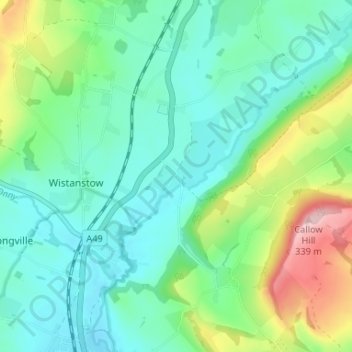
Name: Topografische Karte Strefford, Höhe, Relief.

Ort: Strefford, Wistanstow, Shropshire, England, SY7 8DE, United Kingdom (52.44573 -2.83981 52.48573 -2.79981)

Durchschnittliche Höhe: 175 m

Minimale Höhe: 118 m

Maximale Höhe: 335 m

👉 Easily get elevation data in JSON, GeoTIFF and KML formats using Elevation API
Vielen Dank für die Unterstützung dieser Website ❤️
Spenden

Andere topografische Karten

Klicken Sie auf eine Karte, um ihre Topografie, ihre Höhe und ihr Relief anzuzeigen.

Wistanstow

United Kingdom > England > Shropshire > Wistanstow

Durchschnittliche Höhe: 195 m