
Spenden
Topografische Karte Rodon
Klicken Sie auf die Karte, um die Höhe anzuzeigen.
Spenden
Über diese Karte
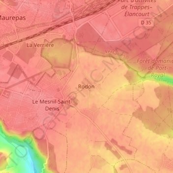
Name: Topografische Karte Rodon, Höhe, Relief.
Durchschnittliche Höhe: 167 m
Minimale Höhe: 112 m
Maximale Höhe: 179 m
Spenden
Andere topografische Karten
Klicken Sie auf eine Karte, um ihre Topografie, ihre Höhe und ihr Relief anzuzeigen.
Versailles
France > Ile-de-France > Yvelines
Versailles is located 17.1 km (10.6 mi) west-southwest from the centre of Paris. The city sits on an elevated plateau, 130 to 140 metres (425 to 460 ft) above sea-level (whereas the elevation of the centre of Paris is only 33 m (108 ft) above sea level), surrounded by wooded hills: in the north the forests of…
Durchschnittliche Höhe: 142 m
Spenden
Montfort-l'Amaury
France > Ile-de-France > Yvelines
Montfort-l'Amaury lies north of the Rambouillet Forest. It is located at the foot of low hills, at about 130 m above sea level. Montfort-l’Amaury has a land area of about 5.71 km², with an elevation of approximately 130 meters above sea level. As of the latest legal census, the population is around 2,790…
Durchschnittliche Höhe: 152 m
Spenden
Versailles
France > Ile-de-France > Yvelines
Versailles is located 17.1 km (10.6 mi) west-southwest from the centre of Paris. The city sits on an elevated plateau, 130 to 140 metres (430 to 460 ft) above sea level (whereas the elevation of the centre of Paris is only 33 m (108 ft) above sea level), surrounded by wooded hills: in the north the forests of…
Durchschnittliche Höhe: 142 m
Spenden
Spenden
Le Vésinet
France > Ile-de-France > Yvelines
The terrain is an alluvial plain ranging in altitude from 28 meters near Le Pecq to 45 meters at the end of the Route de Montesson, with a gentle slope from northeast to southwest.
Durchschnittliche Höhe: 37 m
Versailles
France > Ile-de-France > Yvelines
Versailles is located 17.1 km (10.6 mi) west-southwest from the centre of Paris. The city sits on an elevated plateau, 130 to 140 metres (430 to 460 ft) above sea level (whereas the elevation of the centre of Paris is only 33 m (108 ft) above sea level), surrounded by wooded hills: in the north the forests of…
Durchschnittliche Höhe: 142 m
Spenden
Spenden
Spenden
Buc
France > Ile-de-France > Yvelines
The old town lies in the valley of the River Bièvre at an elevation of around 100 m above sea level. Most of Buc's residential districts have been built on the plateau de Saclay, some 50 m higher.
Durchschnittliche Höhe: 151 m
Spenden
Spenden
Park of Versailles
France > Ile-de-France > Yvelines > Versailles > Satory
Durchschnittliche Höhe: 124 m
Spenden
Spenden
Buc
France > Ile-de-France > Yvelines
The old town lies in the valley of the River Bièvre at an elevation of around 100 m above sea level. Most of Buc's residential districts have been built on the plateau de Saclay, some 50 m higher.
Durchschnittliche Höhe: 151 m