
Topografische Karte Maxillou
Interaktive Karte
Klicken Sie auf die Karte, um die Höhe anzuzeigen.
Über diese Karte
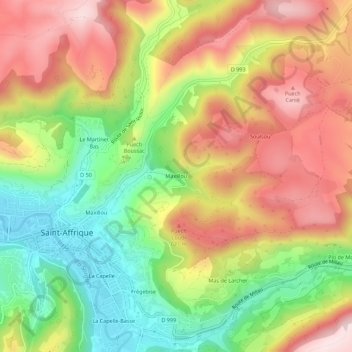
Name: Topografische Karte Maxillou, Höhe, Relief.
Durchschnittliche Höhe: 508 m
Minimale Höhe: 317 m
Maximale Höhe: 697 m
Andere topografische Karten
Klicken Sie auf eine Karte, um ihre Topografie, ihre Höhe und ihr Relief anzuzeigen.
Les Combes
France > Occitanie > Aveyron > Saint-Affrique
Les Combes, Saint-Affrique, Millau, Aveyron, Occitanie, France métropolitaine, 12400, France
Durchschnittliche Höhe: 469 m
Vaxergues-le-Bas
France > Occitanie > Aveyron > Saint-Affrique
Vaxergues-le-Bas, Saint-Affrique, Millau, Aveyron, Occitanie, France métropolitaine, 12400, France
Durchschnittliche Höhe: 442 m
La Foux
France > Occitanie > Aveyron > Saint-Affrique
La Foux, Saint-Affrique, Millau, Aveyron, Occitanie, France métropolitaine, 12400, France
Durchschnittliche Höhe: 567 m
La Capelle
France > Occitanie > Aveyron > Saint-Affrique
La Capelle, Saint-Affrique, Millau, Aveyron, Occitanie, France métropolitaine, 12400, France
Durchschnittliche Höhe: 460 m
Maxillou
France > Occitanie > Aveyron > Saint-Affrique
Maxillou, Saint-Affrique, Millau, Aveyron, Occitanie, France métropolitaine, 12400, France
Durchschnittliche Höhe: 470 m