
Topografische Karte Mansfield
Interaktive Karte
Klicken Sie auf die Karte, um die Höhe anzuzeigen.
Über diese Karte
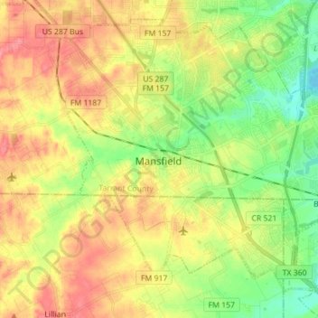
Name: Topografische Karte Mansfield, Höhe, Relief.
Ort: Mansfield, Tarrant County, Texas, 76063, United States (32.51209 -97.18674 32.61612 -97.04678)
Durchschnittliche Höhe: 195 m
Minimale Höhe: 160 m
Maximale Höhe: 231 m
Andere topografische Karten
Klicken Sie auf eine Karte, um ihre Topografie, ihre Höhe und ihr Relief anzuzeigen.
Forest Hill
United States > Texas > Tarrant County
Forest Hill, Tarrant County, Texas, United States
Durchschnittliche Höhe: 198 m
Forest Hill
United States > Texas > Tarrant County > Forest Hill > Forest Hill
Forest Hill, Tarrant County, Texas, 76119, United States
Durchschnittliche Höhe: 195 m
Fort Worth
United States > Texas > Tarrant County
Fort Worth, Tarrant County, Texas, United States
Durchschnittliche Höhe: 212 m
Arlington
United States > Texas > Tarrant County > Arlington
Arlington, Tarrant County, Texas, United States
Durchschnittliche Höhe: 174 m